Ayacucho region
| Ayacucho region | |||
|---|---|---|---|
| Symbols | |||
|
|||
| Basic data | |||
| Country | Peru | ||
| Capital | Ayacucho | ||
| surface | 43,814.8 km² | ||
| Residents | 688,700 (2015) | ||
| density | 16 inhabitants per km² | ||
| founding | April 25, 1822 | ||
| ISO 3166-2 | PE-AYA | ||
| Website | www.regionayacucho.gob.pe (Spanish) | ||
| politics | |||
| Gobernador regional | Carlos Rua Carbajal (2019-2022) | ||
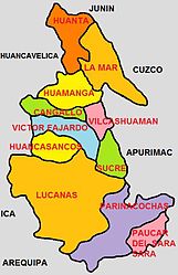
| Provinces of the Ayacucho region | |||
Coordinates: 13 ° 10 ′ S , 74 ° 13 ′ W
The Ayacucho region [ aʝaˈkutʃo ] ( Spanish Región Ayacucho , Quechua Ayakuchu suyu ) is an administrative region in southern Peru . 688,700 people (2015) live in an area of 43,815 km². The capital is Ayacucho .
geography
The Andes shape the landscape; the average altitude is 2761 meters above sea level. The highest mountain is the Sarasara with 5453 meters. The Río Apurímac and Río Mantaro cut the country and provide for a milder climate on their banks.
population
More than three quarters of the population are indigenous ; 63.9% speak Quechua (variant Chanka ) as their mother tongue.
history
The region was founded on February 15, 1825 as a department under Simón Bolívar .
The Sendero Luminoso group originated in the region and was most widespread there.
Provinces
The Ayacucho region is divided into eleven provinces and 119 districts (as of 2019).
Web links
- http://www.regionayacucho.gob.pe/ Regional government of the Ayacucho region
Individual evidence
- ^ Instituto Nacional de Estadistica e Informatica: Census 2007. p. 117 , accessed on September 1, 2018 (Spanish).


