Amazon region
| Amazon region | |||
|---|---|---|---|
| Symbols | |||
|
|||
| Basic data | |||
| Country | Peru | ||
| Capital | Chachapoyas | ||
| surface | 39,249.1 km² | ||
| Residents | 422,600 (2015 estimate) | ||
| density | 11 inhabitants per km² | ||
| founding | November 21, 1832 | ||
| ISO 3166-2 | PE-AMA | ||
| Website | www.regionamazonas.gob.pe (Spanish) | ||
| politics | |||
| Gobernador regional | Oscar Altamirano Quispe (2019-2022) |
||
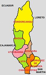
| Provinces of the Amazon region | |||
Coordinates: 6 ° 14 ′ S , 77 ° 52 ′ W
The Amazonas [ amaˈsonas ] (Spanish Región Amazonas , Quechua Amazonas suyu ) is an administrative region in northwestern Peru . In 2015, 422,600 inhabitants lived in an area of 39,249 km². The capital is Chachapoyas .
geography
The area was founded as a department on November 21, 1832 and named after the Amazon river , which, however, only arises from the confluence of the Río Marañón , Río Huallaga and Río Ucayali in the Loreto region . Only the Marañón River crosses the Amazon region. The south of the region lies in the Andes , the north and northeast slowly flatten out - crossed by individual mountain ranges - towards the Amazon basin. In the west the Amazonas region is bounded by the river Marañón and in the north Ecuador joins it.
Rivers
Lakes
- Condor Lake -Laguna de los Condores (Chachapoyas-Leymebamba)
- El Porvenir (Bagua Aramango)
- Laguna de Chonza (Bagua-Copallín)
- Pomacochas (Bongará) - at over 2000 meters
Passports
- Barro Negro ( 3680 m , Chachapoyas)
- Miguel Pardo ( 2930 m , Bongará and Rioja)
- Chanchilla ( 2212 m , Chachapoyas)
- Campanquiz ( 1200 m , Condorcanqui)
climate
Even if the Amazon region is home to many different types of climate, such as tropical forests and high mountains, there is a change between rainy and dry seasons. The rainy season lasts roughly from November to March, the dry season from March to October. Contrary to popular belief, the regional capital of Chachapoyas is not located in the tropical rainforest, but in a climate that is called “Ceja de Selva” in Spanish, which means “the eyebrow of the jungle”. That is, it is on top of the mountain behind which it flattens out towards the rainforest.
population
The Amazon is home to the aguaruna . 13% of the population have the Aguaruna language as their mother tongue. The dominant language in the region is Spanish (86%).
economy
The Amazon region is a region with agricultural potential. The economy consists almost entirely of agriculture and livestock. Rice is grown in warmer and water-rich parts, while other parts have potatoes, corn, wheat, yucca, coffee, coca, bananas and many different types of fruit, especially citrus fruits. There is also fishing, timber production, trade and tourism in some places. The most important hydropower plant in the area is located in Caclic on the Utcubamba River in Chachapoyas Province and has a capacity of 1.5 megawatts. According to a study by the Ministry of Energy and Mines, 55.4% of Amazon's residents are connected to the electricity grid.
traffic
In addition to bridges, roads and fords , the Amazon region also has several river ports: Rentema ( Bagua ), Nazareth ( Bagua ), Choros ( Utcubamba ) and Galilea ( Condorcanqui ).
Administrative division
The Amazon region is divided into seven provinces and these in turn into a total of 82 districts.
| province | Capital |
|---|---|
| Bagua | Bagua |
| Bongará | Jumbilla |
| Chachapoyas | Chachapoyas |
| Condorcanqui | Santa Maria de Nieva |
| Luya | Lámud |
| Rodríguez de Mendoza | Mendoza |
| Utcubamba | Bagua Grande |
Web links
Individual evidence
- ↑ Instituto Nacional de Estadistica e Informatica: 2017 census. Idioma o lengua con el que aprendió hablar. Retrieved October 9, 2018 (Spanish).
- ↑ ESTADÍSTICA ELÉCTRICA POR REGIONES 2005 ( Memento from June 20, 2009 in the Internet Archive )


