Río Santiago
| Río Santiago | ||
|
Río Santiago in Peru |
||
| Data | ||
| location |
|
|
| River system | Amazon | |
| Drain over | Río Marañón → Amazon → Atlantic Ocean | |
| Confluence of |
Río Zamora and Río Namangoza 3 ° 0 ′ 7 ″ S , 78 ° 13 ′ 11 ″ W |
|
| Source height | approx. 340 m | |
| muzzle |
Río Marañón Coordinates: 4 ° 26 ′ 6 ″ S , 77 ° 38 ′ 25 ″ W 4 ° 26 ′ 6 ″ S , 77 ° 38 ′ 25 ″ W. |
|
| Mouth height | approx. 160 m | |
| Height difference | approx. 180 m | |
| Bottom slope | approx. 0.67 ‰ | |
| length | 270 km | |
| Catchment area | 33,640 km² | |
| Discharge at the water level in Puerto Santiago A Eo : 24,700 km² Location: 230 km above the mouth |
MQ Mq |
1530 m³ / s 61.9 l / (s km²) |
| Outflow A Eo : 33,640 km²
|
MQ Mq |
1780 m³ / s 52.9 l / (s km²) |
| Left tributaries | Río Yaupi | |
| Right tributaries | Río Coangos | |
| Communities | Puerto Galilea | |
|
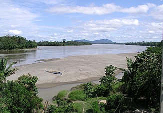
Río Santiago near La Poza (Condorcanqui, Amazonas, Peru), 55 km above the mouth |
||
The Río Santiago is a 270 km long left tributary of the Río Marañón , the left headwaters of the Amazon , in Ecuador and Peru .
River course
The Río Santiago arises in the sub-Andean mountain region at the confluence of the Río Zamora (right) and Río Namangoza (left). It initially flows 65 km in an easterly direction through the Ecuadorian province of Morona Santiago . The trunk road E40 to Puerto Morona follows the course of the river. The Río Yaupi flows into the river from the north. This then crosses the border to Peru and flows on the remaining stretch of the river in a southerly direction through the Amazon lowlands of the Condorcanqui province . Puerto Galilea , the administrative seat of the Río Santiago district , is located at river kilometer 55 on the right bank of the river. The Río Santiago finally meets the flowing eastward Río Marañón, 7.5 km above the Engpaßstelle Pongo de Manseriche .
Protected areas
The National Park Ichigkat Muja - Cordillera del Condor is located in Peru along the border west of the Río Santiago. A ridge separates the lower reaches of the Río Santiago from the further east running Río Morona . The Santiago Comaina Conservation Area extends over this ridge.
Hydrology
The Río Santiago drains an area of 33,640 km². Of these, 26,176 km² are in Ecuador. The mean discharge is 1780 m³ / s.
Web links
Individual evidence
- ↑ A. Laraque, J. Ronchail et al. a .: Heterogeneous Distribution of Rainfall and Discharge Regimes in the Ecuadorian Amazon Basin. In: Journal of Hydrometeorology. 8, 2007, p. 1364, doi: 10.1175 / 2007JHM784.1 .
- ↑ Water Resources Assessment of Ecuador (PDF, 1.0 MB) United States Southern Command, US Army Corps of Engineers, Mobile District and Topographic Engineering Center (web.archive.org). September 1998. Retrieved January 12, 2019.

