Jumbilla District
| Jumbilla District | ||
|---|---|---|
 The district of Jumbilla is located in the central south of the province of Bongará (marked in red) |
||
| Symbols | ||
|
||
| Basic data | ||
| Country | Peru | |
| region | Amazon | |
| province | Bongará | |
| Seat | Jumbilla | |
| surface | 159 km² | |
| Residents | 1385 (2017) | |
| density | 8.7 inhabitants per km² | |
| founding | December 26, 1870 | |
| ISO 3166-2 | PE-AMA | |
| Website | www.munibongara.gob.pe (Spanish) | |
| politics | ||
| Alcalde Provincial | Rómulo Flumencio Vargas Más (2019-2022) |
|
| Political party | Movimiento Regional Fuerza Amazonense | |
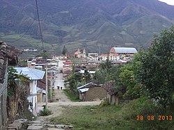
| Jumbilla city view | ||
Coordinates: 5 ° 54 ′ S , 77 ° 48 ′ W
The Jumbilla district is located in the Bongará province in the Amazonas region in northern Peru . The district was founded on December 26, 1870. It has an area of 159 km². The 2017 census counted 1385 inhabitants. In 1993 the population was 1362, in 2007 it was 1569. The administrative seat is the provincial capital Jumbilla at 1935 m high with 1140 inhabitants (as of 2017).
Geographical location
The Jumbilla district is located in the central south of the Bongará province. The Río Chiriaco (also Río Imaza ) crosses the district in a north-northwest direction.
The district of Jumbilla is bordered to the west by the districts of Valera , San Carlos and Cuispes , to the northwest by the Florida district , to the northeast by the Corosha district and to the east by the districts of Chisquilla , Recta , Asunción and Chiliquín (the last two in the province of Chachapoyas ).
Web links
- Municipalidad Provincial de Bongará
- Peru: Amazonas region (provinces and districts) at www.citypopulation.de

