
Tacna region
| Tacna region | |||
|---|---|---|---|
 .svg) |
|||
| Symbols | |||
|
|||
| Basic data | |||
| Country | Peru | ||
| Capital | Tacna | ||
| surface | 16,075 km² | ||
| Residents | 341,800 (2015) | ||
| density | 21 inhabitants per km² | ||
| ISO 3166-2 | PE-TAC | ||
| Website | www.regiontacna.gob.pe (Spanish) | ||
| politics | |||
| Gobernador regional | Juan Tonconi Quispe (2019-2022) |
||
 |
|||


Coordinates: 17 ° 55 ′ S , 70 ° 17 ′ W
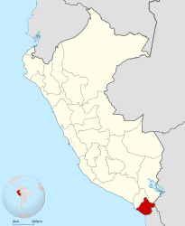
The region of Tacna [ ˈtakna ] (span. Región Tacna , Quechua Taqna suyu ) is the southernmost region of Peru . It borders on the Pacific to the west, Bolivia to the east and Chile to the south . 341,800 people (2015) live in an area of 16,075 km². The regional capital is Tacna .
geography
The landscape is very mountainous, the snow-capped Chupiquiña mountain reaches an altitude of 5788 meters.
population
The most common mother tongues are Spanish (76%), Aymara (19%) and Quechua (3%).
Provinces
The region is divided into four provinces and 24 districts.
| province | Capital |
|---|---|
| Candarave | Candarave |
| Jorge Basadre | Locumba |
| Tacna | Tacna |
| Tarata | Tarata |
history
The province was occupied by Chile in the Saltpeter War in 1880 . Although it was awarded to Peru in the Treaty of Ancón in 1883 , contrary to the agreement, it remained occupied by Chile until 1929. The Tacna-Arica compromise by US President Herbert Hoover then led to the final return of the province to Peru.
Web links
Individual evidence
- ↑ Instituto Nacional de Estadistica e Informatica: 2017 census. Idioma o lengua con el que aprendió hablar. Retrieved October 9, 2018 (Spanish).
Amazon | Ancash | Apurímac | Arequipa | Ayacucho | Cajamarca | Callao | Cusco | Huancavelica | Huánuco | Ica | Junín | La Libertad | Lambayeque | Lima | Loreto | Madre de Dios | Moquegua | Pasco | Piura | Puno | San Martín | Tacna | Tumbes | Ucayali
Lima Province (region-free area of the capital)