Kañaris district
| Kañaris district | |
|---|---|
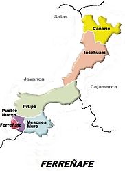
 Location of the Kañaris district (colored yellow) in the Ferreñafe province |
|
| Basic data | |
| Country | Peru |
| region | Lambayeque |
| province | Ferreñafe |
| Seat | KANARIS (Cañaris) |
| surface | 284.9 km² |
| Residents | 11,366 (2017) |
| density | 40 inhabitants per km² |
| ISO 3166-2 | PE-LAM |
| Website | munikanaris.gob.pe (Spanish) |
| politics | |
| Alcalde District | Antonio Ventura Lizana (2019-2022) |
Coordinates: 6 ° 3 ′ S , 79 ° 16 ′ W
The Kañaris district (alternative spelling: Cañaris district ) is located in the Ferreñafe province in the Lambayeque region in northwestern Peru . The name of the district refers to the resettlement of the Kañari people in this area. The district was established on February 17, 1951. The district has an area of 284.88 km². The 2017 census counted 11,366 inhabitants. In 1993 the population was 11,118, in 2007 13,038. The district administration is based in the village of Kañaris (Cañaris) at an altitude of 2,421 m and with 380 inhabitants (as of 2017).
The Kañaris district is located in the far northeast of the Ferreñafe province. It is located in the Peruvian Western Cordillera east of the continental divide . The area is drained via the Río Cañariaco and other mountain streams to the northeast to the Río Huancabamba .
The Kanaris district is bordered to the north by the district Pomahuaca , in the northeast on the district Pucara , in the southeast of the district Querocotillo , the south by the district of Incahuasi and to the west by the district Salas .
Individual evidence
- ↑ a b PERU: Lambayeque region - provinces and districts . www.citypopulation.de. Retrieved March 26, 2020.