Manuel Antonio Mesones Muro District
| Manuel Antonio Mesones Muro District | |
|---|---|
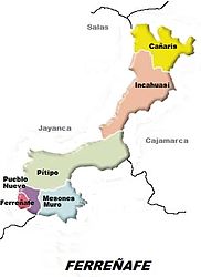
 Location of the Manuel Antonio Mesones Muro district (colored light blue) in the Ferreñafe province |
|
| Basic data | |
| Country | Peru |
| region | Lambayeque |
| province | Ferreñafe |
| Seat | Manuel Antonio Mesones Muro |
| surface | 209 km² |
| Residents | 3808 (2017) |
| density | 18 inhabitants per km² |
| founding | 17th February 1951 |
| ISO 3166-2 | PE-LAM |
| Website | munimanuelantoniomesonesmuro.gob.pe (Spanish) |
| politics | |
| Alcalde District | Jose Mercedes Ramirez Huamán (2019-2022) |
Coordinates: 6 ° 39 ′ S , 79 ° 44 ′ W
The Manuel Antonio Mesones Muro district is located in the Ferreñafe Province in the Lambayeque region in northwestern Peru . The district was named after Manuel Antonio Mesones Muro (1862-1930), an explorer of northeastern Peru. The district was established on February 17, 1951. It has an area of 209 km². The 2017 census counted 3,808 inhabitants. In 2007 the population was 4083. The district administration is located in the 62 m high town of Manuel Antonio Mesones Muro with 1787 inhabitants (as of 2017). Manuel Antonio Mesones Muro is located 5 km east of the provincial capital Ferreñafe at the foot of a foothill of the Peruvian Western Cordillera .
The Manuel Antonio Mesones Muro district is located in the southwest of the Ferreñafe province. It has a lengthwise extension in west-east direction of almost 20 km and a maximum width of 18 km. It is located on the edge of the coastal plain of northwestern Peru east of the provincial capital Ferreñafe and extends about 80 percent over the desert-like foothills of the mountains. Irrigated agriculture is only practiced in the west of the district in the coastal plain.
The Manuel Antonio Mesones Muro district bordered on the north by the district Pitipo , in the northeast on the district Chongoyape , in the southeast of the district Pátapo , in the southwest to the districts Tuman and Picsi and the west by the district of Ferreñafe .
Individual evidence
- ↑ a b PERU: Lambayeque region - provinces and districts . www.citypopulation.de. Retrieved March 26, 2020.