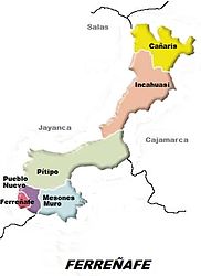
Ferreñafe district
| Ferreñafe district | |||
|---|---|---|---|
 Location of the Ferreñafe District (colored purple) in the Ferreñafe Province |
|||
| Symbols | |||
|
|||
| Basic data | |||
| Country | Peru | ||
| region | Lambayeque | ||
| province | Ferreñafe | ||
| Seat | Ferreñafe | ||
| surface | 62.2 km² | ||
| Residents | 34,229 (2017) | ||
| density | 550 inhabitants per km² | ||
| ISO 3166-2 | PE-LAM | ||
| Website | www.muniferrenafe.gob.pe (Spanish) | ||
| politics | |||
| Alcaldesa Provincial | Violeta Patricia Muro Mesones (2019-2022) |
||
| Political party | Alianza para el Progreso | ||
| Iglesia de Santa Lucía and Plaza de Armas in Ferreñafe | |||
Coordinates: 6 ° 38 ′ 20 ″ S , 79 ° 47 ′ 19 ″ W
The Ferreñafe District is located in the Ferreñafe Province in the Lambayeque Region in northwestern Peru . The district has an area of 62.18 km². The 2017 census counted 34,229 inhabitants. In 1993 the population was 28,885, in 2007 32,665. The seat of the district administration is the 67 m high provincial capital Ferreñafe with 33,526 inhabitants (as of 2017). Ferreñafe is located 16 km north-northeast of the regional capital Chiclayo .
The Ferreñafe District is located in the southwest of the Ferreñafe Province. It is located in the coastal plain of northwestern Peru. Some irrigated agriculture is practiced in the outskirts of the city.
The Ferreñafe district borders in the southwest with the Pueblo Nuevo district , in the northwest with the Mochumí district , in the north with the Pítipo district , in the east with the Manuel Antonio Mesones Muro district and in the south with the Picsi and Lambayeque districts .
Individual evidence
- ↑ a b PERU: Lambayeque region - provinces and districts . www.citypopulation.de. Retrieved March 27, 2020.


