Cordillera Volcánica (Peru)
The Peruvian Cordillera Volcánica is a chain of imposing volcanoes that lies in southern Peru and is part of the western Andes cordillera . It extends parallel to the Pacific coast from the south of the Ayacucho region through the Arequipa , Moquegua and Tacna regions to the Chilean border.
geology
All volcanoes were formed in the Pliocene (late Tertiary ) or Quaternary and have a high mountain character. The volcanism is due to the subduction of the Nazca plate under the South American plate . In contrast to the north and center of Peru, the Nazca plateau dips so steeply in the south of the country that it can be melted. This explains the lack of volcanoes in the northern and central areas of Peru.
The vast majority of the volcanoes of Peru are stratovolcanoes . The most common volcanic rocks are andesite and dacite . But there are also very young cinder cones , especially in the area of the Valle de los Volcanes , which is in the north of the Coropuna .
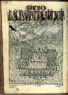
The Sabancaya and Ubinas volcanoes were active in the 21st century . The most devastating volcanic eruption in historical times was that of the Huaynaputina volcano , which exploded on February 19, 1600 . According to the chronicler Guaman Poma de Ayala, an ash shower darkened the city of Arequipa for 30 days.
Overview of the most important volcanoes in Peru
| Name of the volcano | height | Coordinates | Last outbreak |
|---|---|---|---|
| Coropuna | 6425 m | 15 ° 31 ′ 13 ″ S, 72 ° 39 ′ 26 ″ W. | Holocene |
| Ampato | 6288 m | 15 ° 49 ′ 14 ″ S, 71 ° 52 ′ 48 ″ W. | ? |
| Solimana | 6093 m | 15 ° 24 ′ 27 ″ S, 72 ° 53 ′ 29 ″ W. | ? |
| Chachani | 6075 m | 16 ° 11 ′ 39 ″ S, 71 ° 31 ′ 55 ″ W. | ? |
| Hualca Hualca | 6025 m | 15 ° 43 ′ 15 ″ S, 71 ° 51 ′ 33 ″ W. | ? |
| Sabancaya | 5976 m | 15 ° 47 ′ 12 ″ S, 71 ° 51 ′ 27 ″ W. | 2016 |
| Misti | 5825 m | 16 ° 17 ′ 50 ″ S, 71 ° 24 ′ 39 ″ W. | 1787 |
| Tutupaca | 5780 m | 17 ° 1 ′ 34 ″ S, 70 ° 22 ′ 17 ″ W. | 1902 |
| Barroso | 5741 m | 17 ° 33 ′ 18 ″ S, 69 ° 52 ′ 14 ″ W. | ? |
| Ubinas | 5672 m | 16 ° 20 ′ 59 ″ S, 70 ° 53 ′ 47 ″ W. | 2009 |
| Pichu Pichu | 5664 m | 14 ° 26 ′ 30 ″ S, 71 ° 26 ′ 30 ″ W. | ? |
| Casiri | 5650 m | 17 ° 28 ′ 10 ″ S, 69 ° 48 ′ 50 ″ W. | ? |
| Yucamane | 5550 m | 17 ° 11 ′ 2 ″ S, 70 ° 11 ′ 47 ″ W. | 1902 |
| Sara Sara | 5505 m | 15 ° 19 ′ 45 ″ S, 73 ° 26 ′ 44 ″ W. | ? |
| Huarancante | 5420 m | 15 ° 43 ′ 49 ″ S, 71 ° 31 ′ 30 ″ W. | ? |
| Ticsani | 5408 m | 16 ° 45 ′ 32 ″ S, 70 ° 35 ′ 51 ″ W. | ? |
| Huaynaputina | 4850 m | 16 ° 36 ′ 54 ″ S, 70 ° 51 ′ 7 ″ W. | 1600 |
Between Orcopampa and Andagua in the Arequipa region is the Valle de los Volcanes with around 80 small volcanic cones that are less than 3000 years old.
![]() Map with all coordinates: OSM | WikiMap
Map with all coordinates: OSM | WikiMap
Mythological meaning
The high peaks of southern Peru and Bolivia, including the snow-capped volcanoes of both countries, have been the home of the Apus for the indigenous population at least since the Inca period . These deities provide protection and a regular water balance, which is of crucial importance for agriculture in this rather dry region. During the time of the Incas, processions were carried out to many of these volcanoes so that the Apus were well disposed towards the inhabitants. The priests and their followers climbed the peaks and offered their sacrifices to the Apus, mostly lamas, but not infrequently also human sacrifices . The most famous example of this is the Ampato volcano , on the summit of which the mummified, frozen body of a young girl was discovered. She became an archaeological sensation under the name Juanita .
Web links
- igp.gob.pe (picture gallery and text, Spanish)
- Cordillera Volcánica on Peakbagger.com (English)

