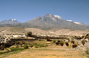
Chachani
| Chachani | ||
|---|---|---|
|
The Chachani |
||
| height | 6057 m | |
| location | Arequipa region , Peru | |
| Mountains | To the | |
| Coordinates | 16 ° 11 '36 " S , 71 ° 31' 53" W | |
|
|
||
| Type | Stratovolcano | |
The Chachani (also Nevado Chachani ) is a mountain north of Arequipa , in southern Peru . Like Misti , northeast of Arequipa, it is also of volcanic origin. Its summit is 6057 meters above sea level.
Ascent
Technically, the Chachani and the Misti do not present any difficulties. The Chachani can be reached in one day via serpentines and paths. Since 2007/2008 it has been free of snow at the end of the dry period (until the end of November). The rest of the time, crampons are required, and a safety device with an ice ax and rope may be necessary if there is a lot of fresh snow. The melting and thawing of the permafrost causes considerable and very dangerous rockfall, which makes climbing difficult. Due to the changes, a new route is being planned, which should be opened from 2009.
Agencies in Arequipa offer two-day tours, but an ascent in one day is also possible. The cost of a two-day tour is around $ 130. The guests are brought to an altitude of around 5000 meters in an off-road vehicle, from where the first base camp can be reached in around 1.5 hours. Since oxygen masks are usually not part of the equipment, an acclimatization phase is necessary. The ascent to the summit, which takes around six to eight hours, begins at night and then reaches the summit in the late morning.
See also
Web links
- Chachani in the Global Volcanism Program of the Smithsonian Institution (English)
Individual evidence
- ↑ Peru: 22 Mountain Summits with Prominence of 1,500 meters or greater. In: Peaklist.org. Retrieved August 13, 2012 .
- ↑ Another victim of global warming: Chachani volcano now without snow at www.enperublog.com

