
Chivay
| Chivay | ||
|---|---|---|
|
Coordinates: 15 ° 31 ′ S , 71 ° 41 ′ W Chivay on the map of Peru
|
||
| Basic data | ||
| Country | Peru | |
| region | Arequipa | |
| province | Caylloma | |
| Residents | 5000 | |
| Detailed data | ||
| height | 3635 m | |
| Time zone | UTC -5 | |
| City Presidency | Jorge Modesto Cueva Tejada | |
 |
||

Chivay is a city in the Colca Valley , capital of the Caylloma Province in the Arequipa region in southern Peru . The city is located at an altitude of 3635 m on the upper reaches of the Río Colca , which forms a canyon downstream that is more than 1000 meters deep. Chivay has a central public square and a lively market. Ten kilometers east of Chivay and 1500 meters higher are the obsidian fields of Chivay, from whose obsidian, for example, more than 90 percent of the statues around Lake Titicaca are made.
Three kilometers downriver from Chivay there are well-developed thermal springs in the ravine of the Río Colca, and on the northern edge of the city a stone "Inca bridge" crosses the river. The city is a popular stopover for tourists who visit "Cruz de Condor" from here, where you can watch the flight of the Condor, which is carried by thermal updrafts for kilometers downstream. Fifteen kilometers northwest of Chivay, the Nevado Mismi massif rises at an altitude of 5597 m , on whose northwest flank the source of the Amazon can be found.
Web links
- Chivay, Peru, to Colca Canyon ( English )
- Photos of Chivay, Peru Colca Canyon Country ( English )
- Hiking along Rio Colca - from Chivay to Sibayo ( English )
- A Colca Canyon tour with the king of the skies
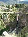
Inca Bridge at Chivay
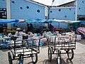
Chivay Market

Temple Santiago Apostol de Caporaque, Chivay


