Talara Province
| Talara Province | |
|---|---|
 Location of the province in the Piura region |
|
| Basic data | |
| Country | Peru |
| region | Piura |
| Seat | Talara |
| surface | 2,799.5 km² |
| Residents | 144,150 (2017) |
| density | 51 inhabitants per km² |
| founding | March 16, 1956 |
| ISO 3166-2 | PE-PIU |
| Website | www.munitalara.gob.pe (Spanish) |
| politics | |
| Alcalde Provincial | José Alfredo Vitonera Infante (2019-2022) |
| Political party | Seguridad y Prosperidad |
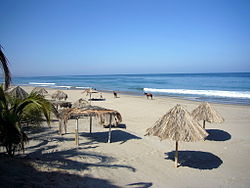
| Beach in Máncora | |
Coordinates: 4 ° 27 ′ S , 81 ° 6 ′ W
The Talara Province is one of eight provinces in the Piura region in northwestern Peru . The province has an area of 2799.49 km². At the 2017 census, 144,150 people lived in the province. In 1993 the population was 120,904, in 2007 129,396. The provincial administration is located in the city of Talara .
Geographical location
The province of Talara is located on the Pacific coast in the northwest of the Piura region. It stretches over a largely desert landscape and extends up to 43 km inland. The longitudinal extent in north-south direction is about 75 km. The mountains on the eastern provincial border reach heights of up to 1122 m .
The province of Talara borders the Tumbes region in the north, the Sullana province in the east and the Paita province in the south .
Administrative division
The province of Talara is divided into six districts (distritos) . The Pariñas district is the seat of the provincial administration.
| District | Administrative headquarters |
|---|---|
| El Alto | El Alto |
| La Brea | Negritos |
| Lobitos | Lobitos |
| Los Órganos | Los Órganos |
| Máncora | Máncora |
| Pariñas | Talara |
Individual evidence
- ↑ a b PERU: Administrative Division - Regions and Provinces . www.citypopulation.de. Retrieved December 14, 2019.
