Paita district
| Paita district | |||
|---|---|---|---|
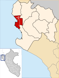
 The district of Paita is located in the southwest of the province of Paita (marked in red) |
|||
| Symbols | |||
|
|||
| Basic data | |||
| Country | Peru | ||
| region | Piura | ||
| province | Paita | ||
| Seat | Paita | ||
| surface | 762.8 km² | ||
| Residents | 87,979 (2017) | ||
| density | 115 inhabitants per km² | ||
| founding | March 30, 1861 | ||
| ISO 3166-2 | PE-PIU | ||
| Website | www.munipaita.gob.pe (Spanish) | ||
| politics | |||
| Alcalde Provincial | Teodoro Alvarado Alayo (2019-2022) |
||
| Political party | Acción Popular | ||
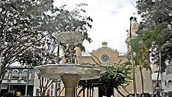
| Plaza de Armas in Paita | |||
Coordinates: 5 ° 5 ′ S , 81 ° 7 ′ W
The Paita District is located in the Paita Province of the Piura Region in northwestern Peru . The district was established on March 30, 1861. It has an area of 762.76 km². In the 2017 census, there were 87,979 residents in the district. In 1993 the population was 42,491, in 2007 72,522. The administrative seat is the provincial capital Paita , located in the northwest of the district on the coast, with 81,163 inhabitants (as of 2017). In addition to Paita, the district also has the coastal towns of La Islilla (2011 inhabitants), La Tortuga (2948 inhabitants) and Yacila (1671 inhabitants) located further south.
Geographical location
The Paita District extends over the coastal desert in the southwest of the Paita Province. It has a coastline on the Pacific Ocean of about 63 km. The Paita – Piura road crosses the district in an easterly direction.
The district of Paita borders in the northwest on the district Colán , in the east on the district La Huaca and in the southeast on the districts La Unión ( province of Piura ) and Vice ( province of Sechura ).
Individual evidence
- ↑ a b Peru: Piura - Provinces & Districts . www.citypopulation.de. Accessed March 31, 2020.


