La Huaca District
| La Huaca District | |
|---|---|
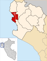
 The district of La Huaca is located in the east of the province of Paita (marked in red) |
|
| Basic data | |
| Country | Peru |
| region | Piura |
| province | Paita |
| Seat | La Huaca |
| surface | 575 km² |
| Residents | 12,950 (2017) |
| density | 23 inhabitants per km² |
| founding | June 21, 1825 |
| ISO 3166-2 | PE-PIU |
| Website | munilahuaca.gob.pe (Spanish) |
| politics | |
| Alcalde District | Juan Carlos Acaro Talledo (2019-2022) |
| Political party | Acción Popular |
Coordinates: 4 ° 55 ′ S , 80 ° 58 ′ W
The La Huaca district is located in the Paita province of the Piura region in northwestern Peru . The district was established on June 21, 1825. It has an area of 575 km². At the 2017 census, there were 12,950 residents in the district. In 1993 the population was 9,164, in 2007 10,867. The administrative center is the 22 m high town of La Huaca with 4387 inhabitants (as of 2017). La Huaca is located on the south bank of the Río Chira about 25 km northeast of the provincial capital Paita and almost 50 km northwest of the regional capital Piura .
Geographical location
The La Huaca district is located in the east of the Paita province. The district stretches across the coastal desert of northwestern Peru. The Río Chira runs along the northern district boundary to the west. The lengthwise extension in north-south direction is almost 40 km, the maximum width about 20 km. In the north there is partly irrigated agriculture. The Paita – Piura road crosses the desert-like south of the district in a west-east direction. In the north the road runs from Paita to Sullana , also in a west-east direction. The settlement areas of the district are located along this.
The La Huaca district is bordered to the west by the district Paita , in the northwest to the districts Colán , El Arenal , Amotape and Tamarindo , on the north by the district Ignacio Escudero ( province Sullana ), in the far northeast of the district Marcavelica (also in the province Sullana), in the east to the Miguel Checa district (also in the Sullana province) and in the south to the La Unión district ( Piura province ).
Locations in the district
In addition to La Huaca, there are the following small towns and larger towns in the district:
- 31 de Octubre – Fatima (943 inhabitants)
- El Porton (230 inhabitants)
- Macacara (662 inhabitants)
- Miraflores (590 inhabitants)
- Nomara (800 inhabitants)
- Pucusula (352 inhabitants)
- Viviate (4666 inhabitants)
Individual evidence
- ↑ a b Peru: Piura - Provinces & Districts . www.citypopulation.de. Accessed March 31, 2020.