Vichayal District
| Vichayal District | |
|---|---|
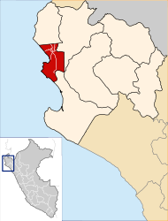
 The district of Vichayal is located in the far northwest of the province of Paita (marked in red) |
|
| Basic data | |
| Country | Peru |
| region | Piura |
| province | Paita |
| Seat | San Felipe de Vichayal |
| surface | 160 km² |
| Residents | 5622 (2017) |
| density | 35 inhabitants per km² |
| founding | August 28, 1920 |
| ISO 3166-2 | PE-PIU |
| Website | munivichayal.gob.pe (Spanish) |
| politics | |
| Alcalde District | Victor Manuel Salinas Ipanaqué (2019-2022) |
| Political party | Partido Democrático Somos Perú |
| Satellite image of the Pacific coast; the district of Vichayal is in the right third of the picture | |
Coordinates: 4 ° 52 ′ S , 81 ° 4 ′ W
The district of Vichayal is located in the Paita Province of the Piura region in northwestern Peru . The district was established on August 28, 1920. It has an area of 160 km². At the 2017 census, there were 5,622 residents in the district. In 1993 the population was 5315, in 2007 5015. The administrative seat is the 16 m high town of San Felipe de Vichayal with 2243 inhabitants (as of 2017). San Felipe de Vichayal is located on the north bank of the Río Chira about 25 km north of the provincial capital Paita and about 10 km from the sea. In addition to San Felipe de Vichayal, there is also the small town of Miramar in the district with 2086 inhabitants.
Geographical location
The district of Vichayal is located in the extreme northwest of the province of Paita. The district stretches across the coastal desert of northwestern Peru. The Río Chira runs along the southern district boundary to the west. In the west, the district has an almost 12 km long stretch of coast on the Pacific Ocean . Irrigated agriculture is practiced near the river. Most of the district is characterized by desert vegetation.
The district of Vichayal borders in the north with the district La Brea ( province Talara ), in the east with the district Amotape and in the south with the district Colán .
Individual evidence
- ↑ a b Peru: Piura - Provinces & Districts . www.citypopulation.de. Accessed March 31, 2020.
