Moss
| Moss | |||
|
|||
| State : |
|
||
| Circle : |
|
||
| Coordinates : | 58 ° 9 ' N , 27 ° 12' E | ||
| Area : | 185.2 km² | ||
| Residents : | 1,570 (01.2006) | ||
| Population density : | 8 inhabitants per km² | ||
| Time zone : | EET (UTC + 2) | ||
| Community type: | former rural community | ||
| Website : | |||

|
|||
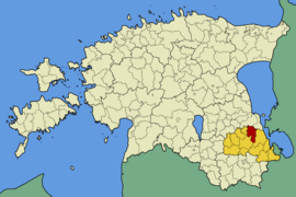
Mooste (Eng. Moisekatz ) is a former rural community in the Estonian Põlva district with an area of 185.2 km². It had 1570 inhabitants (as of January 1, 2006). Mooste has been part of the Põlva municipality since 2017 .
Mooste was founded in 1820 after serfdom was abolished as Moisekatzi-Mooste and was given its current name in 1931.
In addition to the main town Mooste , the rural municipality also included the villages of Jaanimõisa , Kaaru , Kadaja , Kanassaare , Kastmekoja , Kauksi , Laho , Rasina , Säässaare , Säkna , Savimäe , Suurmetsa , Terepi and Viisli .
The imposing manor house of Mooste, which has been used as a primary school for many decades, is worth seeing.
Web links
- Website of the municipality of Mooste (Estonian)
- International Art Center MoKS (Estonian and English)

