Motulalo
| Motulalo | ||
|---|---|---|
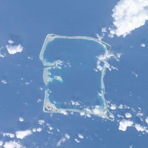
| Satellite image of the Nukufetau Atoll. | ||
| Waters | Pacific Ocean | |
| Archipelago | Nukufetau | |
| Geographical location | 8 ° 4 ′ S , 178 ° 23 ′ E | |
|
|
||
Motulalo is the largest motu in the reefs of the Nukufetau atoll in the island state of Tuvalu .
geography
Motulalo is the most southeastern motu on the southeast tip of the atoll and stretches far north. In the north is the tiny Motuloa , as well as the elongated Congo Loto Lafanga , which leads to the northeast tip at Lafaga .
history
Tradition has it that to protect against raids from Tonga , Tauasa , an aliki (chief) received Motulalo. Whenever enemies appeared, Tauasa tore up coconut palms and threw them at the attackers.
During the Second World War the Americans built the Nukufetau Airfield and a deep-water shipyard on Motulalo. After the war, the runway was dismantled and the land returned to the owners. However, since the coral subsoil was compacted for the construction of the runway, agriculture is hardly possible today.
Individual evidence
- ↑ Map of Nukulaelae Atoll. Tuvaluislands.com.
- ^ British Admiralty Nautical Chart 766 Ellice Islands. 21 March 1872, United Kingdom Hydrographic Office (UKHO) 1893.
- ↑ geonames.org .
- ↑ Hugh Laracy (ed.) Nofoaiga Lafita: Chapter 12 - Nukufetau . In: Tuvalu: A History . Institute of Pacific Studies, University of the South Pacific and Government of Tuvalu, 1983, pp. 86-87.
- ↑ Hugh Laracy (ed.) Melei Telavi: Chapter 18 - War . In: Tuvalu: A History . Institute of Pacific Studies, University of the South Pacific and Government of Tuvalu, 1983, p. 143.

