Mount Katmai
| Mount Katmai | ||
|---|---|---|
|
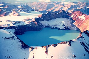
Mount Katmai with crater lake in September 1980 |
||
| height | 2047 m | |
| location | Alaska , USA | |
| Mountains | Alëutenkette | |
| Coordinates | 58 ° 16 '43 " N , 154 ° 57' 25" W | |
|
|
||
| Type | Stratovolcano | |
The Mount Katmai - even Katmai - is a stratovolcano on the Alaska Peninsula in southwest Alaska in Katmai National Park area. It lies in the Alëutenkette and is therefore part of the ring of fire around the Pacific . The rim of the crater reaches a height of 2047 m . The volcano has a diameter of 10 km. In its center there is a 3–4.5 km wide caldera in which a 250 m deep crater lake has formed at an altitude of 1286 m . The Katmai is glaciated.
Historical eruptions of the Katmai are not known. However, 10 km away there was a violent volcanic eruption of Novarupta in June 1912 . As a result of this eruption, the lava chamber below the summit of Katmai collapsed. The caldera, which is still filled with water today, was created.
literature
- Wes Hildreth & Judy Fierstein: The Novarupta-Katmai Eruption of 1912 - Largest Eruption of the Twentieth Century: Centennial Perspectives . USGS Professional Paper 1791, 2012 ( PDF; 36.54 MB )
- Charles Arthur Wood & Jürgen Kienle: Volcanoes of North America: The United States and Canada . Cambridge University Press, 1990, ISBN 978-0-521-43811-7 .
Web links
- Alaska Volcano Observatory: Katmai (English)
- Mount Katmai in the Global Volcanism Program of the Smithsonian Institution (English)

