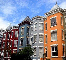
Mount Pleasant (Washington, DC)
| Mount Pleasant Historic District | ||
|---|---|---|
| National Register of Historic Places | ||
| Historic District | ||
|
Mount Pleasant Historic District |
||
|
|
||
| location | Washington, DC | |
| Coordinates | 38 ° 55 '43.3 " N , 77 ° 2' 14.4" W | |
| NRHP number | 87001726 | |
| The NRHP added | 5th October 1987 | |
Mount Pleasant is a neighborhood in northwest Washington, DC It is located between Rock Creek Park to the north and west; Harvard Street NW and the Adams Morgan neighborhood to the south, 16th Street NW and the Columbia Heights neighborhood to the east. About 10,000 people live in Mount Pleasant.
history
In 1727, the governor of the then colony of Maryland , Charles Calvert, gave the lands that now form the Washington neighborhoods of Mount Pleasant, Adams Morgan, Columbia Heights and Pleasant Plains to James Holmead. His son Anthony named the area Pleasant Plains in 1750. After Congress created the District of Columbia in 1791 , Pleasant Plains became part of Washington County, DC, located in the new district. During the American Civil War, the highest part of Pleasant Plains was renamed Mount Pleasant Village.
Mount Pleasant, which, like all residential areas in Washington, DC, was racially segregated due to the segregation that existed in the USA at the time , was an upper middle class residential area until the 1960s. This began in Washington in the 1960s, as everywhere in the USA, to migrate from downtown areas to the suburbs. The 1968 riots in Washington reinforced this trend. At the same time, immigrants from Latin America moved to Mount Pleasant, many of them from El Salvador and the Dominican Republic , and the area developed into a center for Latinos in Washington. Shops that are primarily aimed at Latin American customers now dominate the most important street in the district, Mount Pleasant Street.
Since the late 1980s, a slow gentrification has been observed in Mount Pleasant, and then increasingly clearer from the late 1990s . The district has been listed as a Historic District on the National Register of Historic Places since October 5, 1987 .
Web links
Individual evidence
- ^ Mount Pleasant Historic District on the National Register Information System. National Park Service , accessed August 4, 2017.

