
Nagelfluh outcrop west of Bad Grönenbach

The Nagelfluh outcrop west of Bad Grönenbach , in the district of Unterallgäu ( Bavaria ) is a registered geotope with the number 778A001 in the area of the municipality of Bad Grönenbach . The outcrop is located in the upper area of a western slope at an altitude of 710 m above sea level. NN on the district road MN 21 to Rothenstein and is located in the natural area of the Illervorberge in the geological spatial unit of the Iller- Lech region.
The almost completely overgrown Nagelfluh outcrop was artificially created by mining gravel from the Old Pleistocene . Some remains of geological organs can still be found on the quarry walls. The outcrop is 35 meters long, 10 meters wide and 11 meters high and covers an area of 350 square meters . The well-preserved, unprotected geotope is classified as geoscientifically valuable and is rarely found in the region.
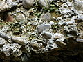
Detail of the outcrop
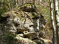
Nagelfluh outcrop


Individual evidence
- ^ Entry in the geotope register of the Bavarian State Office for the Environment
Web links
Coordinates: 47 ° 52 ′ 20.5 ″ N , 10 ° 12 ′ 22 ″ E