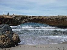
Natural Bridge (Aruba)
Coordinates: 12 ° 32 ′ 28 " N , 69 ° 57 ′ 30" W.
Location of Natural Bridge in Aruba |
The Natural Bridge Aruba ( Dutch Natuurbrug Aruba ) was one of the largest non-man-made bridges in the world and a special attraction on the island of Aruba .
description
The bridge was created by erosion of coral limestone , the surf over the centuries in Andicuri Bay on the northeast side of the island in the stone erodes had. With a total length of 30 meters, it was the largest natural arch bridge of its kind in the Caribbean . The highest point was around 7.6 meters above sea level. It could also be driven on by vehicles.
At dawn on Friday, September 5, 2005, the bridge, which was under protection as a natural monument, collapsed after several small cracks had appeared months earlier.
The bridge was a popular destination for tourists and a popular picnic and swimming spot for the local population. A much smaller bridge is right next to the island's collapsed landmark.
swell
- Newspaper report 5 September 2005 (English)


