Neustädter See (Mecklenburg)
| Neustädter See | ||
|---|---|---|

|
||
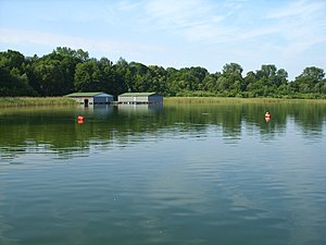
| Boathouses on the Neustädter See | ||
| Geographical location | Ludwigslust-Parchim district | |
| Drain | in the Seegraben 011 | |
| Places on the shore | Neustadt-Glewe | |
| Data | ||
| Coordinates | 53 ° 23 '40 " N , 11 ° 34' 1" E | |
|
|
||
| Altitude above sea level | 33.4 m above sea level NHN | |
| surface | 1.29 km² | |
| length | 1.095 km | |
| width | 825 m | |
| volume | 8.95 million m³ | |
| scope | 4.8 km | |
| Maximum depth | 31.0 m | |
| Middle deep | 6.9 m | |
| PH value | 8.7 | |
| Catchment area | 5.2 km² | |
The Neustädter See is a lake in Neustadt-Glewe in the Ludwigslust-Parchim district in Mecklenburg-Western Pomerania and is considered a typical collapse lake .
description
The lake is located northwest of the built-up urban area in an otherwise poor landscape. With the exception of the bathing establishment on the south-east bank, the water is surrounded by a dense belt of trees. The Neustadt district of Hohes Feld, the former specialist medical center of the Bundeswehr (formerly a military hospital) and a Soviet military cemetery are located near the west bank. In a short distance to the north are the route of the federal highway 24 and the districts of Kronskamp and Hohewisch.
The lake is 1095 meters long and 825 meters wide and has an area of 129 hectares and a volume of 8.95 million m³. The catchment area has a size of 5.2 km². The mean water level is 33.4 meters above sea level . There are no significant tributaries, which is why the water level is mainly influenced by precipitation, evaporation and groundwater feed. On the northeast bank there is a drain to Seegraben 011. Despite the flat, sandy shore zones, the relatively small and funnel-shaped lake reaches a maximum depth of 31 meters.
The basin of the lake was created by post-glacial subsidence, which was caused by leaching in the underground.
In 1867 the body of water was still called the White Lake . The name See Hönwisch , derived from the place Hohewisch, is documented for the year 1262 .
Water quality
Since the mid-1980s, the water quality has suffered mainly due to mass tourism. A mildly eutrophic state was diagnosed from 1994 to 2000 . After the lake was remediated in 1999, when around 25,000 m³ of sediment material was removed from depths below 25 meters, the condition of the water body improved significantly. The lake could already be classified as mesotrophic in 2001 , the depth of view had more than doubled compared to 1998.
In the bathing water map issued by the Mecklenburg-Western Pomerania Ministry of Social Affairs, Neustädter See has achieved the highest water quality level since 2001.
nature
The Neustädter See has a good population of eels, perches, pikes, carp, tench and whitefish. The endangered European strandling occurs in Neustädter See . The lake is part of the Lewitz nature reserve .
Recreation / tourism
Due to the sandy beach with a long shallow water zone, the lake is popular with bathers beyond the city limits. In addition to the official bathing establishment with a pier, there are other unguarded bathing areas. In the immediate vicinity of the lake there is a campsite, holiday and weekend settlements and some dining facilities on the east bank.
Trivia
The Neustädter See is the setting of a legend , according to which there was a monastery in place of the water, which is said to have perished due to the godless behavior of the residents. According to the legend, on bright moonlit nights a mournful monastery woman may appear on the shore, after which the lake takes a victim. One example is a coachman who disappeared into the lake with horses and cart.
See also
Web links
Individual evidence
- ↑ a b c d e f g h i j k Documentation of the condition and development of the most important lakes in Germany: Part 2 Mecklenburg-Western Pomerania (PDF; 3.5 MB)
- ^ Archives for regional studies in the Grossherzogthümen Mecklenburg and Revüe der Landwirtschaft , Volume 17, Schwerin 1867, digitized
- ↑ § 2 para. 1 p. 3 no. 3 of the ordinance on the "Lewitz" landscape protection area in the Ludwigslust district of January 7, 2010 .
- ↑ Hartmut Schmied: The black leaders. Mecklenburg-Western Pomerania , Eulen Verlag, Freiburg 2001, ISBN 3-89102-432-0 , p. 99

