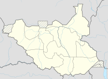
Nimule
Coordinates: 3 ° 36 ' N , 32 ° 4' E
Nimule is a small town in South Sudan on the border with Uganda . It lies on the Nile and belongs to Magwi County in the state of Imatong ( Eastern Equatoria until 2015 ).
During the Second Civil War in South Sudan , Nimule was initially controlled by militias belonging to the indigenous Madi ethnic group . In 1989, however, the city fell to the rebels of the Sudanese People's Liberation Army (SPLA). Many Madi then fled to neighboring Uganda. Nimule became a garrison town in which mainly SPLA soldiers lived, as did Dinka , who fled mainly from Jonglei from the 1990s onwards .
Since the peace agreement in 2005 , Madi have been returning to Nimule. Some of the Dinka displaced persons have also returned to their areas of origin. However, many have settled permanently in Nimule, as the place is considered relatively safe and offers good economic opportunities with cross-border trade. There are also better educational opportunities in nearby Uganda. Returned Madi are therefore often unable to regain their former property, which leads to tension.
In 2006, the population was estimated at around 45,000 and the city was considered to be growing rapidly, despite occasional attacks by the LRA , which had been present in the area since the 1990s.
Nearby is the Nimule National Park .
Individual evidence
- ^ A b Mareike Schomerus, Tim Allen et al .: Southern Sudan at odds with itself. Dynamics of conflict and predicaments of peace ( page no longer available , search in web archives ) Info: The link was automatically marked as defective. Please check the link according to the instructions and then remove this notice. , 2010 (PDF; 5.68 MB), p. 23
- ↑ Boomtown Sudan's Nimule under strain , in: Sudan Tribune, June 11, 2007
