
Eastern Equatoria
| Eastern Equatoria | |
|---|---|
  |
|
| Basic data | |
| Country | South Sudan |
| Capital | Torite |
| surface | 82,542 km² |
| Residents | 906.126 (2008 census) |
| density | 11 inhabitants per km² |
| ISO 3166-2 | SS-EE |
| politics | |
| governor | Louis Lobong |
Coordinates: 4 ° 25 ' N , 32 ° 34' E
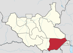
Eastern Equatoria ( Arabic شرق الاستوائية Scharq al-Istawā′iyya , German East Equatoria ) is a federal state in South Sudan .
It has an area of 82,542 km² and according to the 2008 census around 900,000 inhabitants. Its capital is Torit .
geography
Eastern Equatoria is the southernmost state of South Sudan and borders Ethiopia in the east, Kenya and the Ilemi Triangle in the southeast, and Uganda in the south. Aside from the Kobowen Swamp, the vegetation is essentially dry forest .
The state is not located on the eponymous equator , but completely north of it, but is the closest state of South Sudan to the equator.
In Eastern Equatoria lies the Kinyeti , the highest mountain in South Sudan and in all of Sudan. It is part of the Imatong Mountains .
Other places besides Torit are Kapoeta , Magwi , Ikotos , Nimule , Pageri , Owiny Kibul , Parjok , Khiala , Narus , Lafon , Chukudum and Polataka .
population
Ethnic groups in Eastern Equatoria include a. Toposa , Lotuko , Lango , Madi , Acholi and Didinga .
Agropastoralism (cultivation mainly of sorghum and millet, combined with cattle breeding) is the most important livelihood of the population. The infrastructure is sparse in large parts of the state.
history
From 1919 to 1976, the area of what is now the state of Eastern Equatoria belonged to the province of Equatoria . In 1976 the province of Sharq al-Istiwa'iyya, which comprised the area of the present-day states of Eastern Equatoria and Central Equatoria , was split off from the province of Equatoria. From 1991 to 1994 the area belonged again to the newly created state of al-Istiwa'iyya (Equatoria), which resembled the province of Equatoria from 1948 to 1976. On February 14, 1994, al-Istiwa'iyya was divided into three states, with the state of Eastern Equatoria in its current form.
During the second civil war , the Sudanese army and local militias supported by them fought against the rebel army SPLA in Eastern Equatoria . From the beginning of the 1990s, the Lord's Resistance Army from Uganda was also active in Eastern Equatoria, temporarily controlling Magwi County. In 2002 the LRA rebels carried out multiple attacks on villages, killing 470 people. The SPLA received less support in Eastern Equatoria than in other parts of South Sudan, as parts of the population perceived it as an occupying power dominated by the Dinka ethnic group . The area was exposed to air raids as well as fighting by ground forces. Garrison towns such as Torit, Lafon, Kapoeta and Parajok were alternately conquered by the warring parties. Even after the 2005 peace agreement, firearms remained widespread and conflicts between local groups continued.
In the 2010 gubernatorial elections, the ruling party SPLM Louis Lobong Lojore, instead of its previous governor Alesio Ojetuk, was the official candidate. Lobong won the election against Otejuk, who ran as an independent candidate.
administration
Eastern Equatoria, like the other states of South Sudan, is divided into counties. Further administrative units under the counties are Payams and, among them, Bomas. A county commissioner, appointed by the state governor in agreement with the president, presides over the counties. In Eastern Equatoria these are:
- Torit County - County Commissioner: Felix Otuduha Siro
- Lopa / Lafon County - County Commissioner: Caesar Oromo Urbano
- Magwi County - County Commissioner:
- Ikotos County - County Commissioner: Peter Lokeng Lotone
- Budi County - County Commissioner:
- Kapoeta North County - County Commissioner: Lokai Iko Loteyo
- Kapoeta South County - County Commissioner: Martin Lorika Lojam
- Kapoeta East County - County Commissioner: Titos Lokwacuma Lotyam
swell
- ↑ a b c Key Indicators for Eastern Equatoria. Accessed March 31, 2019 .
- ↑ a b Symptoms and causes. Insecurity and underdevelopment in Eastern Equatoria , HSBA Sudan Issue Brief 16, 2010 (PDF; 445 kB)
- ↑ a b Claire Mc Evoy, Ryan Murray: Gauging Fear and Insecurity: Perspectives on Armed Violence in Eastern Equatoria and Turkana North , 2008 (PDF; 1.8 MB)
- ↑ www.statoids.com: Historical overview of the Sudanese states
- ↑ Mareike Schomerus: Violent Legacies: Insecurity in Sudan's Central and Eastern Equatoria (PDF; 602 kB)
- ↑ SPLM candidate in East Equatoria State dominates preliminary results , in: Sudan Tribune, April 21, 2010
- ↑ http://www.gurtong.net/Governance/Governments/GovernmentofSouthSudanStates/EasternEquatoriaState/tabid/330/Default.aspx
Administrative structure since 2017: Akobo | Amadi | Aweil | Aweil East | Bieh | Boma | Central Upper Nile | Eastern Lakes | Fangak | Fashoda | Gbudwe | Gogrial | Gok | Imatong | Jonglei | Jubek | Kapoeta | Latjoor | Lol | Maywut | Maridi | Northern Liech | Northern Upper Nile | Ruweng | Southern Liech | Tambura | Terekeka | Tonj | Twic | Woof | Western Lakes | Yei River
Administrative structure 2015–2017: Amadi | Aweil | Aweil East | Bieh | Boma | Eastern Lakes | Eastern Nile | Fangak | Fashoda | Gbudwe | Gogrial | Gok | Imatong | Jonglei | Jubek | Latjoor | Lol | Maridi | Namorunyang | Northern Liech | Ruweng | Southern Liech | Terekeka | Tonj | Twic | Woof | Western Lakes | Yei River
Administrative division 2011–2015: Central Equatoria | Eastern Equatoria | Jonglei | Lakes | Northern Bahr el Ghazal | Unity | Upper Nile | Warrap | Western Bahr el Ghazal | Western Equatoria