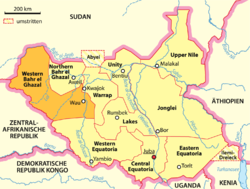
Western Bahr el Ghazal
| Western Bahr el Ghazal | |
|---|---|
 |
|
| Basic data | |
| Country | South Sudan |
| Capital | Woof |
| surface | 93,900 km² |
| Residents | 333,431 (2008 census) |
| density | 3.6 inhabitants per km² |
| ISO 3166-2 | SS-BW |
| politics | |
| governor | Rizik Zachariah Hassan |
Coordinates: 7 ° 45 ' N , 27 ° 52' E
Western Bahr el Ghazal ( Arabic غرب بحر الغزال Gharb Bahr al-Ghazāl , DMG Ġarb Baḥr al-ġazāl 'Western Gazelle River') is a federal state in South Sudan . Its name is derived from the Bahr al-Ghazal or Gazelle River .
It has an area of 93,900 km² and, according to the official result of the 2008 census, around 333,000 inhabitants. Its capital is Wau , other important places are Raja , Deim Zubeir , Kawajena and Kangi .
population
In Western Bahr el Ghazal there are mainly various smaller ethnic groups that are grouped together under the collective name Fertit . The linguistic diversity is great compared to other parts of Sudan.
The still low population density is a late consequence of the slave hunts , the wars and the colonial conquest in the 19th century.
The population in Western Bahr el Ghazal has been culturally influenced by the neighboring parts of Northern Sudan, so "Arabic" clothing, the Arabic language and Islam are more common than in other parts of South Sudan. Western Bahr el Ghazal was therefore hardest hit by the Southern Policy 1930-46, with which the British colonial government tried to prevent northern influences in the south. For this purpose, ethnic groups that were assigned to the north were resettled there, while groups that were considered to be southern were relocated further south to keep them away from northern influences.
geography
The vegetation consists mainly of wet savannah , in contrast to the state of Northern Bahr el Ghazal , which also belongs to the Bahr al-Ghazal region and whose landscape is primarily characterized by dry savannah.
It is an iron ore plateau . Because of the spread of tsetse flies , which transmit the Nagana cattle disease , the keeping of cattle in Western Bahr el Ghazal plays only a minor role, while the neighboring Northern Bahr el Ghazal is one of the most important cattle breeding areas in South Sudan.
history
From 1919 to 1948 the area of what is now the state of Western Bahr el Ghazal belonged to the province of Equatoria and from 1948 to 1976 to the province of Bahr al-Ghazal , which was split off from Equatoria in 1948. From 1991 to 1994 the area of Western Bahr el Ghazal belonged to the newly created state of Bahr al-Ghazal, which resembled the province of Bahr al-Ghazal from 1948 to 1976. On February 14, 1994, Western Bahr el Ghazal was created as a federal state within today's borders.
The area around the town of Kafia Kingi , which had been depopulated as a result of resettlements under the Southern Policy, was separated from Bahr al-Ghazal in 1960 under the military government of Ibrahim Abbud and added to the northern region of Darfur . It has since been disputed between North and South Sudan, with the South claiming it as part of Western Bahr el Ghazal.
During the First Civil War in South Sudan , the Anya Nya rebels were also active in Raga County and carried out an attack on Wau. During the Second War, Wau, Raja, and Deim Zubeir were under government control as garrison towns for most of the time.
The 2010 gubernatorial elections were won by the SPLM candidate , Rizik Zachariah Hassan .
administration
Western Bahr el Ghazal is, like the other states of South Sudan, divided into counties. Further administrative units under the counties are Payams and, among them, Bomas. A county commissioner, appointed by the state governor in agreement with the president, presides over the counties. In Western Bahr el Ghazal these are:
| county | Size (km 2 ) | Population survey 2008 |
County Commissioner |
|---|---|---|---|
| Jur River | 10,032.22 | 127,771 | |
| Raga | 61,792.46 | 54,340 | |
| Woof | 19,251.27 | 151.320 |
swell
- ↑ Key Indicators for Western Bahr El Ghazal (WBG) - The Republic of South Sudan. In: ssnbss.org. October 1, 2011, accessed March 31, 2019 .
- ↑ Map of the results of the 2008 census on unsudanig.org (PDF)
- ↑ a b c d e Edward Thomas: The Kafia Kingi Enclave - People, politics and history in the north-south boundary zone of western Sudan ( Memento from March 20, 2012 in the Internet Archive ), 2010 (PDF; 2.52 MB)
- ↑ Ahmad Alawad Sikainga: The western Bahr al-Ghazal under British rule, 1898-1956 , Ohio University Center for International Studies, 1991, ISBN 0-89680-161-6
- ↑ www.statoids.com: Historical overview of the Sudanese states
- ↑ SPLM candidate for Western Bahr el Ghazal Governor leads preliminary results , in: Sudan Tribune, April 18, 2010
- ^ W. Bahr el Ghazal governor talks up his record but says there is much to do , in: Sudan Tribune, November 2, 2010