
Noordertoren
| Noordertoren | ||
|---|---|---|
 |
||
| Place: | Schiermonnikoog | |
| Location: | Friesland , Netherlands | |
| Geographical location: | 53 ° 29 '11.9 " N , 6 ° 8' 47" E | |
| Height of tower base: | 7 m | |
|
||
| Function: | Lighthouse , radar (since 1979), weather station | |
| Construction time: | 1853-1854 | |

The Noordertoren lighthouse on the Dutch Wadden Sea island of Schiermonnikoog has no official name, but is usually referred to as Noordertoren ( German "North Tower" ). The former second lighthouse on Schiermonnikoog was the Zuidertoren (German "South Tower"). The Noordertoren was built from bricks and natural stone between 1853 and 1854; it has a height of 37 m, so that the lighthouse is 44 m above sea level. The tower has been equipped with radar since 1979 and is manned 24 hours a day. It has been a listed building since 1980 and was painted red in 1998. A weather report is sent from the tower for coastal shipping.
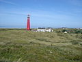
The Noordertoren from the land side (September 2003)
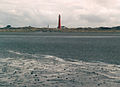
View over the North Sea to Schiermonnikoog with the two lighthouses (February 2004)

View of Schiermonnikoog with lighthouse at dusk (December 2008)


Web links
- Lighthouse In: vvvschiermonnikoog.de
- Lighthouse Noordertoren Schiermonnikoog In: schiermonnikoog.info