Northeast Glacier
| Northeast Glacier | ||
|---|---|---|
|
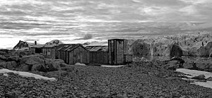
View from Stonington Island with the buildings of the East Base of the United States Antarctic Service Expedition to the mouth of the Northeast Glacier in Marguerite Bay |
||
| location | Grahamland , Antarctic Peninsula | |
| length | 21 km (roughly estimated) | |
| width | Max. 8 km (at the mouth) | |
| Coordinates | 68 ° 9 ′ S , 66 ° 58 ′ W | |
|
|
||
| drainage | Marguerite Bay | |
The Northeast Glacier is a steep and highly rugged glacier on the Antarctic Peninsula . It flows westwards from McLeod Hill and then southwest to Marguerite Bay on the Fallières coast of Graham Land , which it reaches between the Debenham Islands and the Roman Four Promontory .
A first geodetic survey of the area was made in 1936 by participants in the British Graham Land Expedition (1934–1937) under the direction of the Australian polar explorer John Rymill . Another investigation was carried out in 1940 by scientists from the United States Antarctic Service Expedition (1939-1941), who used this glacier as a route for a dog sled excursion and so named it because it northeast (English: northeast ) to the base station of the expedition on the Stonington Island lies.
Web links
- Northeast Glacier in the Geographic Names Information System of the United States Geological Survey (English)
- Northeast Glacier on geographic.org (English)

