Omatako Dam
| Omatako Dam | |||||||
|---|---|---|---|---|---|---|---|
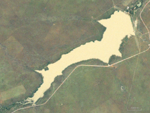
| Satellite photo of the Omatako Reservoir | |||||||
|
|||||||
|
|
|||||||
| Coordinates | 21 ° 9 ′ 0 ″ S , 17 ° 10 ′ 48 ″ E | ||||||
| Data on the structure | |||||||
| Lock type: | Arch weight wall | ||||||
| Construction time: | ? –1981 | ||||||
| Power plant output: | no power plant | ||||||
| Operator: | Namibia Water Corporation | ||||||
| Data on the reservoir | |||||||
| Water surface | 12,545 km² | ||||||
| Maximum depth | 11 m | ||||||
| Storage space | 43.5 million m³ | ||||||
| Catchment area | 5 320 km² | ||||||
The Omatako Dam is a dam in Namibia .
The structure is located around 40 kilometers east of the Omatakoberge and 170 kilometers north of Windhoek . The Omatako dam was completed in 1981 as a gravity dam and serves as a compensation basin for the water balance between karst and savanna.
The Omatako reservoir has a capacity of around 43.5 million cubic meters and is fed by the Omatako River. There is a pumping system for the return to the Von-Bach-Damm .
literature
- JJ Sirunda, D. Mazvimavi: The Effects of Water Transfer from Swakoppoort and Omatako Dams on the Water Quality of Von Bach Dam, Namibia. In: Combating Water Scarcity in Southern Africa . Springer Netherlands, 2014.
Web links
- Official Site of NamWater the dam (English)
Individual evidence
- ^ The Effects of Water Transfer from Swakoppoort and Omatako Dams on the Water Quality of Von Bach Dam, Namibia
- ↑ Omatako Dam. NamWater accessed on September 13, 2014

