
Oststadt (Neubrandenburg)
.JPG)

The Oststadt is part of the urban area of Neubrandenburg and belongs to the eastern urban area.
After the Südstadt, which was built from 1957 to around 1960, the Oststadt is the second coherently planned and implemented residential area in Neubrandenburg from the post-war period . It was created in the 1970s based on a design by Iris Grund , Günter Gisder, Kurt Ehlert, Manfred Hartung and Klaus Radecke; Eberhard Spilker planned the open spaces. The Berlin architect Iris Grund, who was in charge of the project , had already designed the House of Culture and Education in the center of Neubrandenburg . The area was planned back in the 1960s with a prestigious claim.
In the planning phase for the eastern part of the city, very elaborate special buildings were planned, such as a three-legged high-rise on a circular base and multi-segmented snakes. For financial reasons, however, the area was ultimately implemented with only a few types of housing in different arrangements, including one developed only for Neubrandenburg and the WBS 70 . The first WBS-70 block, which was built there in 1973 (Koszaliner Straße 1/3/5/7), is located in the area. It has been a listed building since 1984.

The special thing about the residential area is primarily due to the geological situation. Neubrandenburg is located in an area that was washed out by the Young Alluvium , formed in the second ice age and so very agitated. The area of the settlement is now predominantly on an Ice Age high plateau. From the federal highway 104 as the main development of the district, the streets rise to this high plateau. This was used to line the most important of the entrances into the quarter, the Juri-Gagarin-Ring, with accompanying high-rise buildings. These three emphasize the curved, rising street layout and thus lead spatially into the quarter. The sequence of the three high-rise buildings will then be continued with other, special types of buildings: This Neubrandenburg high-rise residential building type is available in the quarter in a single-kinked variant, in a two-kinked variant and in a variant that swings in once and swings out once. With these three forms an astonishing variety is achieved, which are used in different places as individual structures, as sequences or as contrasts.
Also noteworthy is the preserved mural on ceramic tiles "Children - Dreams - Future" by Erhard Großmann from 1972. It belonged to the school restaurant in Ziolkowskistraße, which was built in 1973 based on a design by Hans Steindl. This school feeding once supplemented the school center, which is centrally located in the Oststadt and consists of numerous individual high schools and the extended high school (Gymnasium), the building complexes of which have now largely been demolished. After the fall of the Wall, the building was fundamentally changed and now houses a retail chain, a restaurant and several smaller shops. In addition, the Lindetal-Center shopping center was built in the 1990s and a new building for the Kaufland retail chain was built across from it in the 2000s .

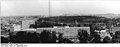
View of the Oststadt in July 1974
View from the HKB tower to the Oststadt in the background, September 1974

Mural "Children - Dreams - Future" at the former school restaurant (Ziolkowskistraße)

Leisure pond "Ihlenpool"


Individual evidence
- ^ Ingrid Halbach, Ernst S. Heideck, Wolfgang Rechlin: Architectural Guide Neubrandenburg. City and surroundings. Berlin 1991, p. 30 and p. 36.
- ^ A b Ingrid Halbach, Ernst S. Heideck, Wolfgang Rechlin: Architectural Guide Neubrandenburg. City and surroundings. Berlin 1991, p. 30.
- ↑ Iris Grund. In: arch INFORM .
- ↑ Gerhard Krenz, Walter Stiebitz, Claus Weidner (ed.): Cities and city centers in the GDR. Results and real perspectives of urban development in the German Democratic Republic. Berlin 1968, pp. 152-153.
- ↑ Gerhard Krenz, Walter Stiebitz, Claus Weidner (ed.): Cities and city centers in the GDR. Results and real perspectives of urban development in the German Democratic Republic. Berlin 1968, p. 153, lower figure.
- ↑ List of monuments in Neubrandenburg (status: 05/2013)
- ↑ Geological map of the German Empire based on the information provided by Dr. C. Vogel's editorship in Justus Perthes' Geographischer Anstalt in Gotha executed map in 27 sheets, Gotha 1894–1897, sheet 8
- ^ Wall painting "Children - Dreams - Future" by Erhard Großmann in 1973 at Panoramio .
- ↑ The mural is signed on a tile in the lower right corner and is dated 1972.
Web links
Coordinates: 53 ° 33 ' N , 13 ° 18' E