Pacaya
| Pacaya | ||
|---|---|---|
|
McKenney Cone |
||
| height | 2552 m | |
| location | Guatemala | |
| Coordinates | 14 ° 22 '58 " N , 90 ° 35' 58" W | |
|
|
||
| Type | complex volcano | |
| Last eruption | 1965, continuously since then | |
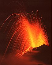
The Pacaya is one of the most active volcanoes in the world. It is located south of Guatemala City and its eruptions can mostly be observed from there. A total of 23 outbreaks were recorded during the Spanish colonial period. After that, activity was dormant for about a century until another violent outbreak occurred in 1965. Since then there has been continuous activity. The eruptions are typically Strombolian with hundreds of explosions every day. The strombolian eruptions are triggered by degassing the magma, they throw glowing lava bombs hundreds of meters into the air and also produce smaller aa lava flows . Pacaya also produces moderate Plinian eruptions sporadically .
The Pacaya is part of a volcanic chain that stretches along the Pacific coast of Guatemala and was formed by subduction of the coconut plate under the Caribbean plate . It is part of a basaltic volcanic complex, which lies on the southern edge of the 15 km² large caldera , the Amatitlán Lake . The complex consists of an older stratovolcano , most of which has formed over the past 23,000 years from domes , tephra and today's stratovolcano. The current volcanic cone constantly changes its shape depending on the building or destructive volcanic forces: Since 1965, the McKenney Cone has grown from the old Cerro Chico crater ( 2265 m ) , which now (2010) has reached a height of 2560 m .
The easiest and safest way to climb Pacaya is to book a tour at one of the travel agencies in Antigua Guatemala , they offer daily tours for around seven to nine dollars. While armed attacks on visitors to the volcano were repeatedly reported in the 1990s, the security situation has improved significantly in recent years, as the volcano and its surroundings were declared a national park in 2000. Since then u. a. Paths and shelters are laid out, and rangers ensure the safety of visitors. If you arrive without an organized tour, you have to buy a ticket at the visitor center in San Francisco de Sales and it is recommended not to climb the volcano without a guide. It takes about three hours, the ascent is not difficult, but strenuous, also because of the altitude. The last 150 meters difference in altitude must be climbed through the deep, loose ash and slag of the summit cone.
In 1998 and at the end of May 2010 the international airport of Guatemala, about 23 km from Pacaya, had to be closed after a violent eruption.
Old crater of the Pacaya volcano, in the background Lake Amatitlán , Guatemala, 2002
Web links
- Pacaya in the Global Volcanism Program of the Smithsonian Institution (English)
- vulkane.net/blogmobil: Pacaya in Guatemala
- Pacaya 1992 on volcano fascination


