
Tikal
| Tikal National Park | |
|---|---|
|
UNESCO world heritage |
|

|
|
| The Tikal Great Square, the North Acropolis and Temple I. |
|
| National territory: |
|
| Type: | Culture / nature |
| Criteria : | (i) (iii) (iv) (ix) (x) |
| Surface: | 57,600 ha |
| Reference No .: | 64 |
| UNESCO region : | Europe and North America |
| History of enrollment | |
| Enrollment: | 1979 ( session 3 ) |
Coordinates: 17 ° 13 ′ 15.4 " N , 89 ° 37 ′ 29.8" W.


Tikal is an ancient city of the Maya in the rain forests of Petén in northern Guatemala with remarkable levels temples . It was one of the most important cities of the classical Maya period (3rd to 9th centuries) and is one of the best-explored Maya cities. The first traces of settlement reach into the early 1st millennium BC. BC back. In the 2nd century the real urban development began with the erection of temples , steles and palace-temple complexes. A first high point was reached in the 5th century when a powerful ruling dynasty subjugated one small state after the other in the neighborhood and made them vassal kingdoms, which resulted in a long-term conflict with the powerful neighboring state of Calakmul . Tikal experienced a second high point in the 8th century after Calakmul was defeated as a rival. In the early 9th century, Tikal's power waned and construction ceased. The city was completely deserted by the 10th century at the latest.
Building the city
Tikal extends over an area of about 65 square kilometers, of which the central area occupies around 16 square kilometers, which has over three thousand buildings. An estimated 10,000 buildings, especially in the outdoor areas, have not yet been excavated and explored. It is estimated that the population of the city center at the height of power in the classical period (8th century) was at least 50,000 and that the immediate agglomeration of the metropolis even reached a population of up to 200,000. As of 2018, researchers believe that the Tikal area numbered at least one million people.
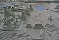
The center of Tikal is the so-called Great Square. It is framed by Temples I and II in east-west as well as by the north and central acropolis in north-south direction; In addition, there was a ball playground between Temple I and the Central Acropolis . Another ball playground existed east of Temple I. The whole place probably served as the embodiment of the Maya worldview, a kind of “cosmic space”: The “heaven”, the north acropolis with further step pyramids, was the place where the rulers of Tikal were buried while the palace to the south of the square embodied the "underworld". This palace had two large galleries and stood on two large platforms. It was built and designed more extensively and elaborately than other comparable buildings. It is considered likely that this palace on the central acropolis served as the royal residence.
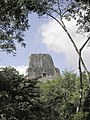
The two temples I and II flanking the Great Square, with their heights of 47 m and 40 m, are among the highest step temples in Central America. Exactly 100 steps lead up to the sanctuary of Temple I (also known as the Temple of Ah Cacao or Temple of the Great Jaguar) at a height of about 35 m.
In the dimensioning and orientation of the buildings in Tikal there are references to a coding of the Mayan calendars and cycles that are significant for the people. For example, from the entrance to Temple Pyramid IV, on two Mayan holy days, the sunrise and sunset can be seen exactly in the roof ridge of Temple Pyramid I, which is in the building's axis. Both dates span 260 days - the length of the sacred Tzolkin calendar. At the same time, they are the key data of the Mayan agricultural cycle, which began on February 12th and ended with the onset of the rainy season on October 30th . How the Maya were able to achieve the necessary structural precision without technical aids is unknown.
history
The historical name of Tikals was probably Mutal , with the emblem glyph representing a bundle knotted together. The exact translation is unclear, maybe it can be translated as “flower”. The earliest settlement of Tikal took place around 900 BC. Instead of what was determined by ceramic finds. It took around five hundred years to erect more complex structures. Around this time, Tikal developed into a leading center of the pre-classical period. Tikal survived the general decline at the end of this epoch (approx. 200 AD), while many other centers of the pre-classical period sank into political insignificance or were abandoned.
Around this time, the influence of the city of Teotihuacán, located in the central Mexican highlands, became visible in the temple architecture. In the year 378 finally an army coming from there or allied with Teotihuacán appeared near Tikal and conquered the city, whereby the reigning ruler Chak Tok Ich'aak I ("Big Jaguar Paw") was killed. However, there is evidence that this "overthrow" took place with the help of a powerful political group within Tikal. It is also believed that people from Teotihuacán moved to Tikal, as the new rulers had also appointed a new ruler. In any case, the new dynasty merged with the old within a short time; at the same time, all cultural references to central Mexico disappeared.
In the middle of the fifth century the first expansionary phase of the city of Tikal began with the first military campaigns under King K'an Chitam recorded on steles . At the same time, however, the hegemonic position that Tikal had so far in the southern lowlands also disappeared . When the ruler Chak Tok Ich'aak II died on a military campaign in 509 , in the absence of a male heir to the throne of the appropriate age, his six-year-old daughter was chosen as the new ruler. However, she was probably not much more than a puppet of the various noble families of the city and in 537 lost control to her brother Chan K'awiil, who had been living in exile until then . These dynastic problems weakened Tikal, but the city was still the leading power in the region.
This changed with the beginning of the conflict with the archenemy Calakmul . Disputes over the status of Caracol , a vassal Tikal, culminated in open war after some time. Tikal was defeated in a battle near the city of Calakmul in 562 and had to tolerate the enthronement of a ruler chosen by Calakmul, which resulted in a period of weakness that lasted over a hundred years, during which hardly any new buildings were erected. This phenomenon, known as the hiatus , probably resulted from the demise of the ally Teotihuacán.
Over the years, the aristocracy (or the ruling dynasty) split into a faction that demanded the independence of Calakmul, and another faction that advocated remaining in his vassal system. When the first faction gained the upper hand in the middle of the seventh century and was able to provide a king with Nuun Ujol Chaak , the Calakmul-friendly nobles emigrated to Dos Pilas , from where they continued to claim the throne of Tikal. In the bitter war that followed, Calakmul succeeded once again in securing supremacy over Tikal, which was deliberately isolated diplomatically in the years that followed.
The indirect rule of Calakmul over other cities, as Tikal had previously practiced itself, was one of the greatest weaknesses in the political system of the Maya kings. In 695 the new king of Tikal Jasaw Chan K'awiil succeeded in inflicting a heavy defeat on Calakmul, occupying the enemy city and re-establishing hegemony over the Maya area. This marked the beginning of the second expansionary phase in Tikal's history. Under Jasaw's successor Yik'in Chan K'awiil , Tikal also defeated all of Calakmul's important allies and installed vassal kings there. The period of the late 7th and all of the 8th centuries was a time of great prosperity, accelerated growth and extensive construction, during which numerous palaces and temples were expanded. The enormous Temple IV also dates from this time.
The city began to decline suddenly at the beginning of the ninth century. The disappearance of dated steles seems to be linked to a loss of power by the elites and an extensive emigration (or even mass death) of the population. The exact causes for the collapse of the entire Maya civilization at this point in time has not yet been clarified and is still hotly debated in research. However, a severe drought in the Yucatán, which began between 800 and 830 and resulted in an extremely dry climate until the 10th century, was possibly a decisive element of the downfall. The last dating of a stele of Tikal comes from the year 879, making Tikal one of the longest surviving classical Mayan cities.

Temple I, 47 m high, looking east

Temple I and Temple II
Temple IV

Temple V

panoramic view
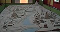
Model of the city center, looking east

View over the palace and the great square
View over the North Acropolis to the south

View from the South Acropolis to the north

Stairs on the pyramid

Pyramids in the jungle


Monuments
Selection of the most important steles and altars; Ruler after Martin and Grube.
| monument | date | Ruler | front | Left | Right | back |
|---|---|---|---|---|---|---|
| Stele 1 | Siyaj Chan K'awiil II |

|
||||
| Stele 2 | Kan Chitam |

|
||||
| Stele 3 | 9.2.13.0.0 (488) | Yax Nuun Ahiin I. |

|

|
||
| Stele 4 | 8.17.10.0.0 (386) |

|
||||
| Stele 5 | 9.15.13.0.0 (744) | Yik'in Chan K'awiil |

|
|||
| Stele 6 | 9.4.0.0.0 (514) | ♀ (Tikal) | ||||
| Stele 7 | 9.3.0.0.0 (495) | |||||
| Stele 8 | 9.0.10.0.0 (445) | Bird Claw | ||||
| Stele 9 | 9.2.0.0.0 (475) | Kan Chitam |

|

|

|
|
| Stele 10 | 9.2.0.0.0 (475) | ♀ Kaloomte 'B'alam |

|

|

|
|
| Stele 11 | 10.2.0.0.0 (869) | Jasaw Chan K'awiil II. |

|
|||
| Stele 12 | 9.4.13.0.0 (527) | ♀ (Tikal) ♀ Kaloomte 'B'alam |

|
|||
| Stele 13 | 9.1.0.0.0 (455) | Kan Chitam |

|

|

|
|
| Stele 14 | 9.5.0.0.0 (534) | |||||
| Stele 16 | 9.14.0.0.0 (711) | Jasaw Chan K'awiil I. | ||||
| Stele 17 | 9.6.13.0.0 (567) | Wak Chan K'awiil | ||||
| Stele 18 | 8.19.0.0.0 (416) | Yax Nuun Ahiin I. |

|
|||
| Stele 19 | Yax Nuun Ahiin II. | |||||
| Stele 21 | Yik'in Chan K'awiil | |||||
| Stele 22 | 9.17.0.0.0 (771) | Yax Nuun Ahiin II. |

|
|||
| Stele 23 | ♀ (Tikal) | |||||
| Stele 24 | Dark Sun | |||||
| Stele 25 | ♀ Kaloomte 'B'alam | |||||
| Stele 26 |

|
|||||
| Stele 29 | 8.12.14.13.15 (292) | |||||
| Stele 31 | Siyaj Chan K'awiil II |

|

|
|||
| Stela 40 | (468) | Kan Chitam | ||||
| Altar 5 | 9.13.19.16.6 (711) | Jasaw Chan K'awiil I. |

|
List of rulers of Tikal
The numerous dated inscriptions of Tikal allow the reconstruction of a ruler's genealogy of at least 33 people over a period of 800 years. Some names that cannot be read completely or with certainty are temporarily given an English "nickname" (nickname). The mother of common children in the line of rulers is also given as “woman”. ♀ stands for the usual English name Lady .
| Surname | Reign | genealog. Item | Alternative names | woman | progeny | dig |
|---|---|---|---|---|---|---|
| Yax Ehb Xook | at 90 | 1 | Yax Moch Xok, Yax Chakte'l Xok, "First stage shark" | |||
| "Leaf Jaguar" (?) | at 292 | ? | ||||
| "Animal headdress" (?) | ? | 10? | Kinich Ehb '? | ♀ "skull" | Siyaj Chan K'awil I. | |
| Siyaj Chan K'awiil I. | at 307 | 11 | - | |||
| ♀ Unem Bahlam | at 317 | 12? | - | |||
| K'inich Muwaan Jol | ? -359 | 13 | Mahk'ina "bird skull", "feather skull" | ♀ Balam Way | Chak Tok Ich'aak I. | |
| Chak Tok Ich'aak I. | 360-378 | 14th | "Jaguar Paw", "Big Paw", "Big Jaguar Paw" | |||
| Yax Nuun Ahiin I. | 379 -404? | 15th | "Curl Snout", "Curl Nose" | ♀ K'inich | Siyaj Chan K'awiil II. | Temple 34 |
| Siyaj Chan K'awiil II. | 411-456 | 16 | "Stormy Sky" | ♀ Ayin | Kan Chitam | Temple 33 |
| K'an Chitam | 458 – around 486 | 17th | Kan Boar, K'an Ak | ♀ Tzutz Nik | Chak Tok Ich'aak II. | |
| Chak Tok Ich'aak II. | approx. 486-508 | 18th | "Jaguar Paw", "Jaguar Paw Skull" | Wak Chan K'awiil, "Woman of Tikal" | ||
| "Woman from Tikal" | approx. 511-527? | |||||
| ♀ Kaloomte 'Bahlam | approx. 511-527 | 19th | "Curly hair" | |||
| "Bird Claw" (?) | ? | 20? | "Animal Skull" I. | |||
| Wak Chan K'awiil | 537-562 | 21st | "Double bird" | |||
| "Animal skull" | 537-562 | 22nd | - | Temple 32 | ||
| Rulers 23 and 24 | approx. 640 | - | ||||
| Nuun Ujol Chaak | approx. 657-679 | 25th | "Shield Skull", Nun Bak Chak | ♀ "Jaguar seat" | Jasaw Chan K'awiil I. | |
| Jasaw Chan K'awiil I. | 682-734 | 26th | Ruler A, Ah Cacao | ♀ Kalajuun Une 'Mo' | Yik'in Chan K'awiil | Temple 1 |
| Yik'in Chan K'awiil | 734 – around 766 | 27 | Ruler B, Yaxkin Caan Chac, "Sun-Sky-Rain" | Nuun Yax Ayiin II., Ruler 28 | ||
| Ruler 28 | approx. 766-768 | 28 | - | |||
| Nuun Yax Ahiin II. | 768 - approx. 794 | 29 | - | |||
| Nuun Ujol K'inich | at 800? | 30? | - | ♀ "Darkened Sun"? | ||
| ♀ "darkened sun" | around 810 | 31? | - | |||
| Jewel K'awiil | around 849 | ? | - | |||
| Jasaw Chan K'awiil II. | around 869 | ? | - |
present
Tikal has never been completely forgotten since the Spanish conquered the highlands of Guatemala and was visited in 1848 by an expedition led by Modesto Méndez and Ambrosio Tut . Your report was first published in German in 1853 in a paper from the Berlin Academy of Sciences . The next visitor in 1877 was the Swiss doctor Carl Gustav Bernoulli , who wrote another report and removed some lintels, the “Tikal panels”, which can be viewed today in the Museum of Cultures Basel . Later Alfred Percival Maudslay in 1881 and Teoberto Maler in 1895 and 1904 intensively researched the ruins, drew plans and took photographs. He was followed in 1910 by Alfred Tozzer and Raymond Merwin . After a long hiatus, the University of Pennsylvania Museum began a huge expedition project in 1956 that lasted until 1969 and produced numerous publications, often with a delay of decades. Since 1979, research on Tikal has been carried out by Guatemalan institutions.
The entire area around Tikal was declared a national park and is now a World Heritage Site . The small airfield in the middle of the facility was closed, an asphalt access road from Flores was built and a tourist infrastructure was built on the road in Tikal.
Trivia
The temples were used in the cult film Star Wars: Episode IV - A New Hope as the filming location for the planet Yavin IV.
See also
literature
- Nikolai Grube : "Lady Ti" and love. The ruler called "Frau von Tikal" is a mystery to research…. In: Adventure archeology . 2005, p. 47 ff.
- Nikolai Grube (Ed.): Maya. God kings in the rainforest. Könemann, Cologne 2000, ISBN 3-8290-1564-X .
- Joyce Kelly: An Archaeological Guide to Northern Central America. Belize, Guatemala, Honduras, and El Salvador. University of Oklahoma Press, Norman OK 1996, ISBN 0-8061-2858-5 , pp. 129-145.
- Simon Martin / Nikolai Grube: Chronicle of the Maya Kings and Queens. Deciphering the Dynasties of the Ancient Maya. Thames & Hudson, 2nd ed., London 2008, ISBN 978-0-500-28726-2 , pp. 24-53.
- John Montgomery: Tikal. An illustrated history. The ancient Maya capital. Hippocrene, New York NY 2001, ISBN 0-7818-0853-7 .
- Rudolf Oeser: Shield Skull: The Maya ruler Nuun Ujol Chaak of Tikal. In: Amerindian Research. No. 1, 2006, ISSN 1862-3867 , pp. 29-38.
- Linda Schele , David Freidel : The unknown world of the Maya. The secret of their culture deciphered. Weltbild Verlag, Augsburg 1995, ISBN 3-89350-737-X .
- James Tickell, Oliver Tickell: Tikal. City of the Maya. Tauris Parke Books, London 1991, ISBN 1-85043-223-6 .
Web links
- Entry on the UNESCO World Heritage Center website ( English and French ).
- Map and photos of the temple ruins. The Maya Ruins Page, January 24, 1999
- Homepage of the Tikal Park
- Maya Lowland Centers: Tikal. In: Athena Review Volume 2, No. 2. 2003, archived from the original on March 3, 2008 ; accessed on September 29, 2016 (English, history of Tikals).
Individual evidence
- ↑ Nikolai Grube : Maya. God kings in the rainforest. 2000, p. 448.
- ^ Peter D. Harrison: The Lords of Tikal. Rulers of an Ancient Maya City. Thames & Hudson, London 2000, ISBN 0-500-28129-7 , p. 9.
- ↑ Laser Scans Reveal Maya "Megalopolis" Below Guatemalan Jungle. In: nationalgeographic.com . February 1, 2018, accessed on February 3, 2018 (English, covering an area of 800 km²).
- ↑ Nikolai Grube: Maya. God kings in the rainforest. 2000, p. 222.
- ↑ Michael D. Coe : The Maya. 6th edition., Fully revised and expanded. Thames & Hudson, London 1999, ISBN 0-500-28066-5 , p. 123.
- ↑ Surveying the Maya temples in Tikal - A German architect campaigns for the heritage of Guatemala. (mp3, 10:45 min) (No longer available online.) Deutschlandradio Kultur, March 10, 2014, formerly in the original ; accessed on March 31, 2014 . ( Page no longer available , search in web archives ) Info: The link was automatically marked as defective. Please check the link according to the instructions and then remove this notice.
- ^ Peter D. Harrison: The Lords of Tikal. Rulers of an Ancient Maya City. Thames & Hudson, London 2000, ISBN 0-500-28129-7 , p. 30.
- ^ David Webster: The Fall of the Ancient Maya. Solving the Mystery of the Maya Collapse. Thames & Hudson, London 2002, ISBN 0-500-05113-5 , p. 133.
- ↑ Simon Martin, Nikolai Grube: Chronicle of the Maya Kings and Queens. Deciphering the Dynasties of the Ancient Maya. Thames & Hudson, London 2000, ISBN 0-500-05103-8 , p. 40.
- ↑ Simon Martin, Nikolai Grube: Chronicle of the Maya Kings and Queens. Deciphering the Dynasties of the Ancient Maya. Thames & Hudson, London 2000, ISBN 0-500-05103-8 , p. 44 f., P. 110 f.
- ↑ Nikolai Grube: Maya. God kings in the rainforest. 2000, p. 168.
- ↑ Simon Martin, Nikolai Grube: Chronicle of the Maya Kings and Queens. Deciphering the Dynasties of the Ancient Maya. Thames & Hudson, London 2000, ISBN 0-500-05103-8 , p. 227.
- ↑ Richardson B. Gill: The Great Maya Droughts. Water, Life, and Death. University of New Mexico, Albuquerque NM 2000, ISBN 0-8263-2194-1 .
- ↑ Simon Martin, Nikolai Grube: Chronicle of the Maya Kings and Queens. Deciphering the Dynasties of the Ancient Maya. Thames & Hudson, London 2000, ISBN 0-500-05103-8 , pp. 25-53.
- ↑ Simon Martin, Nikolai Grube: Chronicle of the Maya kings and queens. Thames & Hudson, London 2000, ISBN 0-500-05103-8 .
Cerro Miramundo | Cuevas Del Silvino | El Baúl | El Reformador | El Rosario | Grutas de Lanquín | Laguna del Tigre | Laguna El Pino | Laguna Lachuá | Las Victorias | Los Aposentos | Morado Río Azul | Naciones Unidas | Pacaya | Río Dulce | Riscos De Momostenango | San José La Colonia | Sierra del Lacandón | Sipacate Naranjo | Tikal | Yaxhá Nakúm Naranjo

Cultural heritage: Antigua Guatemala (1979) | Mayan ruins and Quiriguá Archaeological Park (1981)
Cultural / natural heritage: Tikal National Park (1979)