
Teotihuacan
| Prehistoric city Teotihuacan |
|
|---|---|
|
UNESCO world heritage |
|

|
|
|
The Pyramid of the Sun and the "Road of the Dead" in Teotihuacán as seen from the Pyramid of the Moon |
|
| National territory: |
|
| Type: | Culture |
| Criteria : | i, ii, iii, iv, vi |
| Reference No .: | 414 |
| UNESCO region : | Latin America and the Caribbean |
| History of enrollment | |
| Enrollment: | 1987 (session 11) |
Coordinates: 19 ° 41 '32 " N , 98 ° 50' 39" W.

Teotihuacán in the Central Highlands of Mexico / State of México is one of the most important prehistoric ruined cities in America, which is best known for its step temples such as the great pyramid of the sun. The archaeological site, which has been a UNESCO World Heritage Site since 1987 , is located near the present-day city of Teotihuacán de Arista , around 45 kilometers northeast of Mexico City .
The area of Teotihuacán had been permanently settled since the sixth century BC. Between 100 and 650 AD, the city was the dominant cultural, economic and military center of Mesoamerica . At the height of its development, it may have had a population of up to 200,000. In its time it was by far the largest city on the American continent and one of the largest in the world. From around 650 its importance waned until it was largely abandoned around 750 for reasons that were not fully understood. Their cultural influences shaped central Mexico until the Spanish conquest of Mexico .
The Aztecs found Teotihuacan when they immigrated to the highlands of Mexico as a ruined city that had been deserted for centuries. They saw it as a mythical place and gave it the name Teotihuacan ( Tēotīhuacān ), which has survived to this day and which means something like where one becomes a god .
After the arrival of the Spaniards in the 16th century, Fray Juan de Zumárraga , the first Archbishop of México- Tenochtitlán and at the same time Inquisitor , and Bishop Diego de Landa had all tangible Mayan documents and manuscripts written in Mayan script burned. The destruction of their altars and images of gods was ordered. In the years following the proclamation of the Viceroyalty of New Spain in 1535, a large part of the population of Mesoamerica was forcibly converted to Christianity. The Aztec culture, which did not have a writing system with which complete texts could be reproduced, gradually disappeared without, however, completely disappearing. In general, almost all pre-Hispanic documents (codices) were destroyed during and after the Spanish conquest.
The town has been excavated since the arrival of the Spaniards in the 16th century. From around 1900, more professional, if initially archaeologically amateur, excavations took place. The lack of written records from the time of origin makes research on Teotihuacán much more difficult. Much knowledge can only be gained through the interpretation of findings.
On March 30, 2015, the memorial was included in the International Register of Cultural Property under the special protection of the Hague Convention for the Protection of Cultural Property in the Event of Armed Conflict .
Location and natural conditions
The ruins are located in central Mexico, northeast of the Valley of Mexico in the Valley of Teotihuacán. This covers an area of a good 500 to 600 square kilometers and is bordered in the north by several extinct volcanoes and in the south by a mountain range with mountains of up to 2800 meters. The valley is traversed by the Río San Juan, which is seasonally fed by several smaller springs and today flows into Lake Xaltocan .
The valley of Teotihuacán has a warm temperate climate ; between 1921 and 1968 an average annual precipitation of 550 millimeters and an annual average temperature of 14.8 degrees Celsius were measured. Winter usually starts in October and can last into May. Then the rainy season begins, which lasts until October , with most of the rain falling in the summer months.
The valley is only partially suitable for agriculture. While the eastern part has mainly shallow soils and there is hardly any water, there are deeper alluvial soils in the western part , and the San Juan has water here all year round due to some springs. In addition, there are also larger deposits of usable raw materials in the immediate vicinity, such as obsidian (especially on the eastern edge of the valley), limestone , clay minerals and several types of volcanic rock. The flora probably consisted of forests with oaks and cypresses in the wetter areas and various shrubs in the drier areas. There were several types of hare and rabbit, rodents, birds, reptiles and one type of deer, the white-tailed deer, of the fauna that could be used by humans .
City layout

The city of Teotihuacán at the height of its development took up an area of more than 20 square kilometers. The city was laid out on the basis of a grid arrangement that was followed exactly. For example, the Río San Juan, which flows through the city, was adapted to the grid through canalization.
The main axis of the city forms the so-called Street of the Dead (in Nahuatl : miccaotli ), which runs through the city with a deviation of 15 ° 30 ′ to the east in a north-south direction, but not continuously, as it is repeatedly interrupted by stair embankments . The northern end of the street forms the pyramid of the moon with the square in front of it and the adjacent Quetzalpapalotl palace. In the south it runs past the Great Compound and the Temple of Quetzalcoatl opposite to the mountain Cerro Gordo , on the summit of which a temple was built. There is also the large court complex, the ciudadela ( citadel ), in which the ruling family or their direct subordinates may have lived. In between, the street is flanked by numerous buildings, which are believed to be residential buildings of the ruling elite due to the great expense with which they were equipped and built.
The center of the city is the pyramid of the sun , after the Great Pyramid of Cholula, the second largest pyramid on the American continent. In front of it is the plataforma adosada (in German roughly "connected platform"), which could have served as a ceremonial space . The zone in which the largest pyramids and the abovementioned upper-class houses were located was separated from the rest of the city by a wall. Most of the buildings outside of it were identified as so-called apartment compounds , large residential complexes designed for multiple families. They were each united in groups ( barrios , Spanish for residential area), which in turn were grouped around a larger compound that had its own temple complex. There were also quarters that were inhabited by members of other peoples, such as the Zapotec , Mixtec and Maya .
In the northwest of Teotihuacán was one of the oldest parts of the city, with a relatively high population density and many temples from the city's early days. The south-west, on the other hand, was rather sparsely populated, since most of the irrigated fields in the immediate vicinity of the city were located there. In the east, agriculture was hardly possible due to the previously described water shortage.

Pyramid of the sun
Main article: Pyramid of the Sun at Teotihuacán
The pyramid of the sun is located in the center of Teotihuacán. With a footprint of 222 m × 225 m, a height of over 65 m and a volume of around one million m 3 , it is the third largest pyramid in the world. It was built in one step around 100 AD, making it the first large building to be built in Teotihuacán. The core of the pyramid consists of about 2 million tons of rammed earth . It got its current name from the Aztecs .
The pyramid today has five levels ; originally there were only four. The archaeological layman Leopoldo Batres tried to restore the pyramid during the uncovering in 1906 and assumed the existence of five steps. In fact, today's fifth stage was created through Batres' work based on this assumption. On the side facing the Street of the Dead, a staircase leads to the top via the plataforma adosada attached to the pyramid . There was a small temple there that can no longer be seen today. At its core, the pyramid consists of adobe and basalt , while the outer skin was covered with stucco and painted, of which nothing has survived today.
In 1968, the entrance to a cave was discovered that led under the pyramid of the sun. In addition to artifacts from the time of Teotihuacán, objects from the Aztec period were also found there. In addition, since caves were repeatedly regarded as places of creation in later Mesoamerican religions, it is assumed that the pyramid served religious purposes. It is not yet certain which god the pyramid of the sun was consecrated to. Today there are no longer any paintings that could prove the worship of a particular god; All that was found was a vessel with an image of the "storm god" (often identified with the later Aztec god Tlaloc ), but this alone is also not conclusive evidence that this god was also worshiped here.
The art historian Esther Pasztory of the American Columbia University nevertheless connects the pyramid with a certain deity, the "Great Goddess". There are some pictures of her that indicate that she was a fertility goddess. In some cases it is also associated with caves. Pasztory's assumption is based on the frequency of images of the Great Goddess and the resulting great importance and on the interpretation of the cave as a typically female symbol.

Lunar pyramid
The pyramid of the moon, located at the northern end of the street of the dead, was built around a century after the pyramid of the sun. With a footprint of 120 m × 150 m, it reaches a height of 46 m. Unlike the pyramid of the sun, it was created in several stages. The earliest lunar pyramid was built around 100 AD; a total of seven construction phases followed until 350. Excavations under the pyramid have revealed several chambers in which human remains have been found. The 43 meter high pyramid was designed as part of a structural complex known as the Moon Plaza.
Esther Pasztory suspects that the lunar pyramid was dedicated to the "storm god", a deity who, according to Pasztory, was responsible for war and sacrifice, but also for political issues.
Ciudadela


The Ciudadela was probably a courtly complex or palace, comparable to the Forbidden City in Beijing . The surrounding walls have a side length of around four hundred meters and largely shield the interior from outside views. The center of the complex is a building complex consisting of residential complexes and the temple of Quetzalcoatl , the "Feathered Serpent" , located in the middle . The Ciudadela could only be reached via a small entrance on the front facing the Street of the Dead. According to George L. Cowgill, the space inside can hold one hundred thousand people and could accordingly have been used for cultic purposes.
The temple in particular has repeatedly aroused the interest of archaeologists. It has a side length of 65 m × 65 m and is built in the tablero-talud style. The construction of the temple took place essentially in three phases. The first phase consisted of a smaller building, which was built over with the second phase. In the second phase, today's pyramid was built, at the same time as the Ciudadela after 200 AD. Later, in the third phase, a plataforma adosada was added, like the other great pyramids. However, due to the sculpture, it can be clearly seen here that the pyramid was dedicated to the god Quetzalcoatl . On the front there are numerous sculptures depicting the head of a feathered serpent. There are, however, other representations of differently shaped heads that have not yet been assigned exactly. The most common interpretation of these other head sculptures today is based on the assumption that they are depicting the heads of an as yet undefined being with headdresses. These heads rest on the body of the feathered snake.
Since Quetzalcóatl also appears as the evening star in later codices , it is also possible that the pyramid was also used to pay homage to the planet Venus . This is also supported by the dimensions of the Ciudadela as a whole, because measured by the Teotihuacán Measurement Unit (TMU; explanation in the Science section ) one side of the wall surrounding the Ciudadela is around 484 TMU long; a number that corresponds almost exactly to the number of days in the Venus cycle when the planet can be seen in the sky as a morning or evening star.
In addition, graves with human remains were repeatedly found in several excavation phases. The graves contained offerings, but some had already been looted by grave robbers at the time of their investigation.
Residential complexes

From the Tlamimilolpa phase (from around 200 AD), older mud-brick houses were replaced by residential complexes known as "apartment compounds". Up to the early Xolalpan phase (from around 300 AD) the residents probably built around 2,200 complexes out of stone, in rare cases also out of mud bricks, masonry and plastered. As a rule, each of the residential complexes had a side length of fifty to sixty meters. In individual cases, however, the dimensions can differ considerably from the average. The rectangular complexes were surrounded by a wall several meters high and had only one entrance. Inside there were many rooms, courtyards and corridors arranged in groups (“apartments”) and at least one temple platform. According to René Millon's estimates, they were inhabited by at least sixty, but probably an average of one hundred or more people.
Each residential complex was built according to a specific plan in a building entrance and was inhabited for centuries; During repairs, the original system was rarely changed. Since there are sometimes quite large differences in terms of equipment and dimensions, the complexes seem to have been inhabited by different social classes. On the basis of this, an attempt was made to reconstruct a social order (see the section on society below). Especially in the lower strata it happened that rooms were also used for handicraft purposes. The residential complexes were also organized in quarters ("barrios"), which represented the next higher organizational form.
The culture of Teotihuacán

society
Teotihuacán's social structure can only be reconstructed indirectly, as there is no direct written evidence. Generally, society in the city is divided into six layers based on the different equipment of the apartment compounds. At the top were the rulers with their families who lived in the compounds in the Ciudadela. Below it appears to have been a layer of high priests and officials, possibly supported by warrior chiefs. Both layers were probably responsible for the organization of the city together; presumably neither group comprised more than a few thousand people. The majority of the population, on the other hand, was part of the middle classes, i.e. farmers and artisans as well as lower priests or officials. The division into these three layers was based on the three compounds Zacuala Palace , Teopancaxco and Xolalpan , each of which represents one layer. The lower class included a smaller number of families who only lived in one or two rooms within a compound and performed minor auxiliary work, such as construction work. The existence of long-distance traders like the Aztecs and a somewhat larger group of porters is also likely, but so far unsecured .
economy
The inhabitants of Teotihuacán obtained most of their food from agriculture. Were cultivated among other maize , beans , Amara startup (with grain-like seeds), pepper , tomatillo (in Nahuatl : tomatl) and pumpkins . Frequent cultivation methods were terracing and irrigation cultivation , in part waterfall cultivation . The existence of irrigation systems used by the residents of Teotihuacán could only be proven by aerial photographs in 1954. The water required for this comes from a system of springs near today's Teotihuacán de Arista , which is possibly fed by underground rivers under the Cerro Gordo. It is possible that there was already a preform of the Chinampas , as they were created by the Aztecs, on soils that had been drained by the extraction of spring water. The farmers in Teotihuacán not only had to provide for their own families, but also to feed the population who did not work in food production. With an assumed requirement of 2000 kcal per capita and day and two hundred working days per year, according to a study by William T. Sanders and Robert S. Santley, depending on the soil conditions, there are surpluses between one (rain-fed) and fifteen additionally fed people (chinampas). Nevertheless, Teotihuacán was unable to get food on its own; food had to be imported for around thirty to fifty percent of the population.
In addition, plants were also collected, such as juniper berries , rushes , purslane , opuntia and some types of herbs. The proportion of these wild plants in the diet cannot be determined with certainty. In addition, animals were hunted, including mainly white-tailed deer , but also rabbits and water birds. Only turkeys and dogs were domesticated, but it is uncertain whether they were kept for nutritional purposes. So far, no traces of slaughter have been found on turkey bones and keeping a dog would not have been profitable enough by far. However, since dog meat was considered a delicacy among the Aztecs, it is believed that this was also true of the early inhabitants of Teotihuacán.
Obsidian was particularly important for the great economic importance of Teotihuacán . Obsidian is particularly suitable for making cutting tools and is relatively easy to work with. The largest obsidian deposits in Mesoamerica are located within a few dozen kilometers of the city and were also exploited at the time. Mainly the high quality green obsidian that was mined in Pachuca, fifty kilometers to the northeast, was used, but there are also occurrences of gray and brown obsidian nearby. Other raw materials used were clay for ceramics, basalt , adobe and tuff for building projects and minerals such as cinnabar from mines in what is now the state of Querétaro for paintings. So far, however, workshops have been proven almost exclusively for obsidian tools and ceramics.
The workshops were very productive due to the manufacturing techniques used, while at the same time the consumption of tools made from obsidian was rather low. A large part of it appears to have been manufactured for export, because while William T. Sanders and Robert S. Santley assumed a consumer number of several million people, the American archaeologist John Clark calculated that possibly ten to twenty craftsmen for the self-sufficiency of the city would have been enough.
Trade, especially long-distance trade, played a major role in Teotihuacan's economy. The exact trading volume cannot be determined. Within the city, trade presumably took place primarily in the Great Compound , a large square across from the Ciudadela on the west side of the Street of the Dead. The existence of smaller markets has not (yet) been proven. With long-distance trade, on the other hand, some of the raw materials were brought into the city, which could only be found in the vicinity to a limited extent or not at all. These include cotton and cocoa from Morelos , hematite , jadeite , turquoise and vermilion from the Chalchihuites culture in Durango and Zacatecas, as well as ceramics from other regions; In addition to ceramics, obsidian tools were exported as mentioned above. The trade led to the great cultural influence of Teotihuacán into what is now Guatemala and the USA.
religion

Wall painting in the Tepantitla residential complex: the pleasures in the “paradise of the rain god” Tlalocan
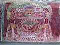
Image of the great goddess of Teotihuacán on a wall in the Tepantitla compound

A tomb discovered by archaeologists. The grave goods indicate a belief in life after death

Fields scratched into the stucco floor for the Patolli game


Religion played a central role in the lives of the people of Teotihuacán. It was polytheistic , that is, there were several gods, each with one or more "tasks". Many of the most important gods were adopted from earlier cultures and still worshiped centuries later by the inhabitants of central Mexico. For this reason, among other things, they are often referred to in research by their later Aztec names when they are unaware of their real name , as far as clear identification was possible. These gods include Quetzalcoatl , the "Feathered Serpent", Tlaloc , the god of rain and agriculture, the "Old God" Huehueteotl , who was worshiped in the pre-classical period in the Cuicuilco settlement and from there came to Teotihuacán, and the “Fat God” as well as Xipe Totec , the skinless god of spring, both gods of fertility. Another important deity was the "Great Goddess". Often a god had several manifestations; for example, Tlaloc could appear as a snake, a bird or a jaguar.
According to their functions, rituals were performed for each god, as wall paintings show. Often sacrifices were made in the process. The question of whether people were also sacrificed was finally clarified during excavations carried out between 1998 and 2004 on the pyramid of the moon. Archaeologists under the direction of Saburo Sugiyama found several graves there with dead, the remains of which showed visible traces of the use of force, but also of people who had been buried alive. Since motifs that are associated with death often appear in art, it is assumed that a cult of the dead existed.
Art and architecture

There are wall paintings in almost all buildings in Teotihuacán. They are the main source for studying the daily life of residents as well as the structure of society. When painting, red was usually used as the background color; the other colors were used to represent the chosen motifs. These are numerous, but they also have a high degree of symbolism. Among other things, mythological and religious representations were dealt with, but also images of people in their everyday activities and above all of high dignitaries and warriors in battle.
Sculptures come in two main forms: those that are directly integrated into the architecture of a building and smaller objects such as smaller figures or masks. For the first group, the sculptures at the Temple of Quetzalcóatl are exemplary, on the facade of which many snake heads are attached to depict the god Quetzalcóatl. Many of the smaller sculptures are made of stone, alabaster, obsidian and other materials and were worked with stone tools. Not infrequently they are decorated with shells or obsidian. Vases and similar vessels, on the other hand, were made of clay. Many of the masks are more likely to be regarded as sculptures, as they have flat backs and no eye or mouth openings and were therefore apparently not intended for human wear.

The buildings in Teotihuacán were usually constructed of stone and adobe . A characteristic feature of the architecture is the so-called Talud-tablero . This term describes the alternation between a vertical surface (tablero) , which protrudes like a box and whose inner field is sunk and often also painted, and an upward and inward sloping slope (talud) . In the classical period of Mesoamerica, the tablero-talud was used not only in Teotihuacán, but also in some other cultures, but the occurrence of this style element is not to be seen as the sole indication of a suzerainty of Teotihuacán, but was rather a general stylistic device at that time.
Another typical characteristic is the high degree of symmetry. This can be seen not only in individual buildings, but also in the arrangement of a single building among several and even in urban planning. Teotihuacán was arranged along two axes in east-west and north-south directions and the entire basic grid was aligned in a certain direction. It is uncertain whether religious motifs also played a role, such as with the Maya .
science

The sophisticated planning of the city layout and the large buildings suggest a high degree of mathematical and astronomical knowledge, although at least the latter cannot be proven. The alignment of the urban planning grid to the sunset on August 12th and April 29th also suggests calendar knowledge, but this can also be explained by the line of sight between the pyramid of the sun and the Cerro Gordo. This interpretation is supported by the discovery of numerous marking circles in and outside of Teotihuacán, which might have been used for surveying. However, this contradicts the fact that such circles were also found inside buildings.
The Teotihuacán Measurement Unit (TMU), a unit of measurement for a length of about 80 to 85 centimeters, was probably decisive for the construction of buildings . It is believed that this unit of measurement was the standard unit of measure of length, on the basis of which the dimensions not only of individual buildings were determined, but also the distances between the most important structures. Ultimately, however, this thesis cannot yet be proven. Nevertheless, it is assumed that the dimensions of many buildings or the distances between buildings, measured in TMU, relate to important calendar data, which were also important in later times.
There is also no evidence of the existence of a fully elaborated script. Although there are glyphs that some researchers see as a developed predecessor of a font, one cannot speak of readable texts here. It is therefore not known which language the inhabitants of Teotihuacán spoke.
history
The history of Teotihuacán had to be completely reconstructed from archaeological finds. In addition to the restrictions that arise with non-written sources, some difficulties arose, as there are a number of finds which, based on their dating, do not seem to match other objects at the site. Although there are explanatory approaches for some finds, a precise time approach for the individual epochs remains difficult to define.
Ascent
The first traces of settlement in the valley of Mexico can be traced back to around 1500 BC. The valley was populated by people from the south, whose descendants with some probability were the later inhabitants of Teotihuacán and the neighboring towns.
During the pre-classical Cuanalan phase (approx. 550 to 150 BC) there were a few villages in the later urban area of Teotihuacán. In the subsequent Patlachique phase (100 BC to the turn of the century), a city with a good 20,000 inhabitants was created, which took up around 6 square kilometers. The city center was in the northwest of the later center. One can only speculate about the appearance of Teotihuacán at this time, as hardly any remains of buildings from the Patlachique phase remained due to later development . For this very reason, the archaeological finds of this era consist almost exclusively of ceramics. During these first two epochs, Teotihuacán was one of several regional centers in the Valley of Mexico. In the first century BC, however, the settlement of Cuicuilco in the southwest of the valley, which had previously been Teotihuacan's greatest competitor, was destroyed by a volcanic eruption. In the following period, the population of Teotihuacán skyrocketed, presumably because the city took in many refugees from Cuicuilco.
In the first two centuries after Christ ( Tzacolli phase up to 150 AD), the basic lines for the current appearance of the city were finally laid. The pyramid of the sun, the street of the dead and a large number of smaller temples were built. How many inhabitants Teotihuacán had at that time can hardly be determined; the estimates are between 30,000 and 80,000 people. However, the city already stretched over an area of over 20 square kilometers and was thus at its greatest extent. The population growth of later centuries was achieved through a higher building density. It is believed that the reasons for the rapid growth are mainly spiritual in nature. This is supported by the existence of a cave under the pyramid of the sun, discovered in 1968, which was demonstrably used for ritual acts, and the construction of the most important temple buildings at a relatively early stage in Teotihuacan's history. The latter would hardly have been possible without a high level of organized administration, which later also favored economic growth. In the following Miccaotli phase (150 to 250), the Street of the Dead, the Cuidadela and the Temple of Quetzalcoatl were also created in the course of dividing the city into four large parts .
Heyday
From the third century on, Teotihuacán finally rose to become the dominant great power . The population increased during the Tlamimilolpa phase (around 200 to 450) to between 100,000 and 200,000 people, who were still concentrated on an area of 20 square kilometers. Instead of the earlier mud brick (Adobe) built houses are now built more housing complexes, called apartment compounds and built over many of the old building. As Teotihuacán's economic power grew, primarily through the trade in obsidian , members of other peoples began to pour into the city, where they lived in their own quarters. The agricultural yields from irrigated agriculture in the valley of Teotihuacán alone were no longer sufficient to feed the population, which is why food had to be imported from the valley of Mexico and from the area of today's Pachuca de Soto .
Teotihuacán's cultural influence began to expand during the Tlamimilolpa phase. The Maya were influenced for the first time in the fourth century and this was reflected in the architecture and art of the period that followed. This can be seen most clearly in the vicinity of the cities of Kaminaljuyú and Tikal . It is not certain whether the influence came about through a military conquest and subsequent direct control by Teotihuacán or otherwise; Only in Tikal is there any evidence of military influence in the year 378.
However, Teotihuacán reached the peak of its development in the Xolalpan phase (around 450 to 650). The city's influence now spanned much of Mesoamerica. In addition to the obvious artistic and architectural similarities among the Maya, trade relations with Teotihuacán and cultural influence can be proven even in the area of the Hohokam culture in today's border area between the USA and Mexico. In the city itself the settlement increased again.
Decline
It seems that as early as the first half of the sixth century Teotihuacan's great cultural influence began to wane. This led to cultural crises that lasted for several decades in the respective areas, especially among the Maya. The construction activity in Teotihuacán remained unbroken; there was even a renewed concentration of the population, until finally around 90 percent of the total population of the valley of Teotihuacán lived in the city itself.
Only from 650, with the beginning of the Metepec phase, did the population begin to shrink for unknown reasons. The city seems to have gradually lost its original importance as an economic center to competitors until it could no longer be self-sufficient. Around 750 there was an almost complete collapse. The most important buildings in the center of the city were burned down, but most of the other quarters remained largely undamaged. There are no signs of an attack from outside. It is therefore assumed that the inhabitants themselves caused the destruction in a ritual act, as is already known from the Olmecs . At the same time, around 80 percent of the remaining population left the city. The assumption that an extremely cold year (535–536) , which is historically proven in Europe, Africa and Asia, would have had this lasting effect, cannot be verified. Against this thesis speaks that outside the valley of Teotihuacan no corresponding phenomenon can be found. After the city was surrendered , a power vacuum existed in central Mexico for around two centuries that could not be filled by any other smaller center until the Toltecs finally gained supremacy in the 10th century.
After a short break, there was renewed, albeit not very numerous, settlement in the outer quarters. However, the residents were unable to restore Teotihuacan's previous great cultural and economic influence. Likewise, the handicrafts no longer achieved their former quality. The last residents left the city at least a century after the city center was destroyed. However, the city was never completely forgotten, instead it became an important place of pilgrimage. The Aztecs , in particular, worshiped Teotihuacán as they saw the place as the place where the world was created and their gods were born.
exploration
Colonial reports and first excavations


Even after the subjugation of the Aztecs by the Spanish conquistadors between 1519 and 1521, Teotihuacán was never completely forgotten. Spanish chroniclers such as Bernardino de Sahagún , Toribio de Benavente Motolinía , Gerónimo de Mendieta and his pupil Juan de Torquemada mention the city in their writings. In 1675 Carlos de Sigüenza y Góngora had some excavations carried out in the area of the lunar pyramid and a tunnel dug into the lunar pyramid. His work was the first archaeological excavation on the American continent. Teotihuacán is also mentioned in Alexander von Humboldt's Views of the Cordilleras and Monuments of the Indigenous Peoples of America , although it is not clear from the work whether he visited the ruins himself. In 1864 the Comisión Científica de Pachuca had the pyramids measured and their geographic coordinates determined and a map of the area drawn up.
Nevertheless, the interest of archaeologists at the time concentrated mainly on the Maya sites discovered in the mid-19th century . In 1884/85 the Mexican Leopoldo Batres began a series of excavations and restored some of the monuments. However, it has been heavily criticized because artifacts were repeatedly damaged during the excavations and, in the eyes of many archaeologists, it did not work scientifically. These allegations were not entirely unfounded, because Batres was not a trained archaeologist, but had acquired his knowledge through self-study. However, his measures also resulted in the Mexican state agreeing to finance further research programs.
Intensification of research
In 1915, the German archaeologist Eduard Seler summarized and analyzed the findings so far in his work The Teotiuacan Culture [sic!] Of the highlands of México . He interpreted the ruins as relics of an outstanding culture that played an important role within a unified cultural tradition. From 1917 to 1922 Manuel Gamio then led the excavation work in Teotihuacán, a student of the German anthropologist Franz Boas and since 1917 director of the newly founded Dirección de Antropologia . He had the temple of Quetzalcóatl restored and undertook an investigation of the stratigraphic sequence. After the end of the excavations, he published the results of his research in the three-volume work La población del Valle de Teotihuacán . In it, Gamio compared the original indigenous population with the later mixed race population in social and cultural terms. For this purpose he examined in his work, among other things, the geographical and geological conditions of the terrain, the physical condition of the pre-Columbian inhabitants, their religious views, their architecture and also their works of art, whereby this part almost exclusively related to sculptures. He came to the conclusion that the indigenous society was losing influence and was threatened with the loss of its cultural identity in the present.
Gamio's work finally aroused the interest of the professional world. In 1922, in the course of an investigation of the types and styles of ceramics, it was determined that one would first have to research Teotihuacan's relationships to other cultures in Mesoamerica in order to be able to reconstruct the development of the city itself. In the 1930s, George Vaillant and Eduardo Noguera tried to take up this conclusion. They found similarities in ceramic style with finds from the Mexican states of Guanajuato , Michoacán , Jalisco and Zacatecas .
The Swede Sigvald Linné then found the first apartment compound in 1932 with the Xolalpan compound; The discovery of the Tlamimilolpa compound followed in 1942. With the Mazapa culture he was able to differentiate an earlier culture from the Teotihuacans for the first time. Its results were published in the first comprehensive excavation reports on Teotihuacán. Alfonso Caso also found the Tlalocán wall paintings in 1940 , which provided a first picture of the daily life of the residents of Teotihuacán. Another study in the Viking complex (named after the foundation that financed the study) made it possible in 1944 to define at least some cornerstones of the chronology. The head of the excavation, Pedro Armillas, succeeded in combining different architectural and ceramic styles.
The major archaeological projects of the 1960s and 1970s
In the 1950s, the Mexican National Institute for History and Anthropology (Spanish Instituto Nacional de Antropología e Historia ) took over the excavation work and mainly had several other compounds examined. The Proyecto Teotihuacán , initiated in 1960, focused in particular on the structures along the Street of the Dead. In addition to the Quetzalpapalotl Palace, a total of ten other new buildings were uncovered, whereby the ceremonial center was discovered. In addition to the excavation of previously unexplored buildings, the focus was on the discovery of wall paintings and friezes, but efforts were also made to make the excavation site more accessible to tourists. After 1962 the project was intensified and the ceremonial center was restored. Eventually it became possible to set up a complete sequence of ceramic styles.
In 1962, the University of Rochester began the large-scale Teotihuacán Mapping Project . By 1970, the area of Teotihuacán was systematically mapped and the boundaries of the city itself sought. For this purpose, the urban area was divided into 500 by 500 meter grid squares and all the buildings found were measured. In 1973 the first results of the study were published. The main result of the project was the creation of a detailed map of the old city and its surroundings; in addition, one could now understand the development of the city. The project also gave a real impression of the importance of Teotihuacán for the first time and formed the basis for many later studies.
Meanwhile, between 1960 and 1975, as part of the Teotihuacán Valley Project, archaeological surveys were carried out throughout the Valley of Mexico to investigate the early settlement history of the valley. The focus was on the agricultural and demographic development as well as the development of the institutions of early high cultures.
Recent research

From 1970 one devoted itself again to the ceremonial complexes and the compounds. The Proyecto Arqueológico Teotihuacán examined between 1980 and 1982 the social and economic structure of Teotihuacán as well as the scientific status, for example in the fields of astronomy and mathematics . Among the objects examined were the Temple of Quetzalcóatl, the Ciudadela and some residential complexes. Up until the nineties, studies were carried out on the spatial organization of the individual compounds and their integration into the overall economic system. The first attempt was also made to research political history. Further research deals with pottery , the environment and obsidian processing .
The excavations continue unabated, while at the same time the number of tourists is steadily increasing.
On August 4, 2010 it was announced that the entrance to the approximately 100 meter long tunnel discovered in 2003 near the Temple of the Feathered Serpent with ground penetrating radar could be located at the expected location. The tunnel was closed for 1,800 years and it has been suggested that the tombs of the rulers of Teotihuacán may be at the other end. In November 2010, the opened tunnel was explored for the first time with a remote-controlled mobile camera. However, a burial chamber was not found after more detailed exploration and inspection of the tunnel.
At the end of 2011, researchers discovered the remains of offerings in the center of the Pyramid of the Sun in Teotihuacán, believed to date from around 100 AD. The researchers hope that the objects made of ceramics, obsidian, jade and animal bones, as well as the seven graves of people who were probably sacrificed ritually, will allow them to draw conclusions about the first settlement of the city.
According to a publication from 2016, an analysis of the bones found in animals (including cottontail rabbits ) revealed that some of them were domesticated. This suggests breeding, possibly to compensate for overhunting larger animals.
exhibition
- 2010; Teotihuacan - Mexico's mysterious pyramid city , Martin-Gropius-Bau , Berlin
See also
- List of pre-Columbian ruins in Mexico (excluding Maya)
literature
- Janet C. Berlo: Art, ideology, and the city of Teotihuacan. A symposium at Dumbarton Oaks; October 8 and 9, 1988. Dumbarton Oaks Research Library and Collection, Washington 1992, ISBN 0-88402-205-6 .
- Kathleen Berrin: Teotihuacan. Art from the city of the gods. Thames and Hudson, London 1993, ISBN 0-500-23653-4 .
- Geoffrey E. Braswell: The Maya and Teotihuacan. Reinterpreting Early Classic Interaction. Texas University Press, Austin 2003, ISBN 0-292-70914-5 (part of the series: The Linda Schele series in Maya and Pre-Columbian Studies ).
- Ursula Eisenhauer: Teotihuacán and its economic foundations. Habelt, Bonn 2000, ISBN 3-7749-2973-4 .
- Eduardo Matos Moctezuma : Teotihuacán. The City of Gods. Rizzoli, New York 1990, ISBN 0-8478-1198-0 .
- Musée du quai Branly (ed.): Teotihuacan. Mysterious pyramid city. Somogy éditions d'art, Paris 2009, ISBN 978-2-7572-0296-8 (catalog of an exhibition in the Musée du quai Branly (October 6, 2009– January 24, 2010), Museum Rietberg Zurich (February 21– 30, 2010) May 2010), Martin-Gropius-Bau (July 1 - October 10, 2010)).
- Esther Pasztory: Teotihuacan. An experiment in living. University of Oklahoma Press, Norman 1997, ISBN 0-8061-2847-X .
- Saburo Sugiyama: Human sacrifice, militarism, and rulership. Materialization of state ideology at the Feathered Serpent Pyramid, Teotihuacan. Cambridge University Press, Cambridge 2005, ISBN 0-521-78056-X .
- Rebecca Storey: Life and Death in the Ancient City of Teotihuacan. A modern paleodemographic synthesis. University of Alabama Press, Tuscaloosa 1992, ISBN 0-8173-0559-9 .
- Literature on Teotihuacán in the catalog of the German National Library
Web links
- Search for Teotihuacán in the German Digital Library
- Search for Teotihuacan in the SPK digital portal of the Prussian Cultural Heritage Foundation
- Teotihuacán, brief overview - photos, drawings + information (English)
- Teotihuacán - Mexico's enigmatic pyramids. German education server
- Info page of the Instituto Nacional de Antropología e Historia (Spanish)
- Entry on the UNESCO World Heritage Center website ( English and French ).
- Article about Teotihuacán on the Minnesota State University website. Archived from the original on June 4, 2010 ; Retrieved January 25, 2014 .
- The World Heritage Site - Teotihuacán
- ASU Teotihuacan Research Laboratory. Arizona State University website
- MesoAmerican Photo Archives: Teotihuacán (English)
- Reconfiguring the Archaeological Sensibility: Mediating Heritage at Teotihuacan, Mexico. Systematic mapping and urbanization studies of Teotihuacan, Stanford University website
Individual evidence
- ↑ John Bierhorst : A Nahuatl - English dictionary and concordance to the Cantares mexicanos with an analytic transcription and grammatical notes. Stanford, Stanford University Press 1985. ISBN 0-8047-1183-6
- ↑ International Register of Cultural Property under Special Protection. UNESCO, July 23, 2015, accessed June 2, 2016 .
- ↑ Ursula Eisenhauer: Teotihuacán and its economic foundations. P. 30
- ↑ Ursula Eisenhauer: Teotihuacán and its economic foundations. P. 28
- ^ A b Ursula Eisenhauer: Teotihuacán and its economic foundations. P. 20
- ^ A b Hanns J. Prem : History of Old America. P. 8.
- ↑ htp: //digibib.hs-nb.de/file/dbhsnb_derivate_0000000509/Diplomarbeit-Tornow-2010.pdf
- ↑ Esther Pasztory: Teotihuacan. An experiment in living.
- ↑ The Mysterious Dead of the Pyramid of the Moon Focus article
- ↑ AR Williams: The Pyramid of Death . National Geographic Germany, Issue 11, 2006, pp. 46–61
- ↑ Esther Pasztory: Teotihuacan. An experiment in living. P. 95 f.
- ↑ George L. Cowgill: Rulership and the Ciudadela. Political Interferences from Teotihuacan Architecture. In: RM Leventhal, AL Kolata (Ed.): Civilization in the Ancient Americas. Essays in Honor of Gordon R. Willey. Albuquerque 1983, pp. 313-343.
- ^ Saburo Sugiyama: Archeology of Teotihuacan, Mexico. Iconography of the Facades at the Feathered Serpent Pyramid: General. ( Memento of June 7, 2013 in the Internet Archive ). Arizona State University, Department of Anthropology, 1996, last updated August 20, 2001.
- ↑ See also Ursula Eisenhauer: Teotihuacán and his economic foundations. P. 22
- ↑ René Millon: Teotihuacan. City, State, and Civilization . In: Jeremy A. Sagloff (Ed.): Handbook of Middle American Indians. Supplement 1, p. 106
- ^ William T. Sanders and Robert S. Santley: A Tale of Three Cities. Energetics and Urbanization in Pre-Hispanic Mexico . In: EZ Vogt and RM Leventhal: Prehistoric Settlement Patterns. Essays in Honor of Gordon R. Willey. Cambridge / Mass. 1983, pp. 243-291
- ↑ Ursula Eisenhauer: Teotihuacán and its economic foundations. P. 41
- ^ William T. Sanders, Robert S. Santley: A Tale of Three Cities. Energetics and Urbanization in Pre-Hispanic Central Mexico . In: EZ Vogt, RM Leventhal (Ed.): Prehistoric Settlement Patterns. Essays in Honor of Gordon F. Willey . Cambridge, Massachusetts 1983, pp. 243-293.
- ^ John E. Clark: From Mountains to Molehills: A Critical Review of Teotihuacan's Obsidian Industry. In: Barry L. Isaac (Ed.): Economic Aspects of Prespanic Highland Mexico. Research in Economic Anthropology. Supplement 2. London 1986, pp. 23-73. Here: p. 40f.
- ^ Eduardo Matos Moctezuma: Teotihuacán. The City of Gods. P. 125
- ↑ AR Williams: The Pyramid of Death. ( Memento of the original from June 11, 2009 in the Internet Archive ) Info: The archive link was inserted automatically and has not yet been checked. Please check the original and archive link according to the instructions and then remove this notice. In: National Geographic Germany. Issue 11, 2006, pp. 46–61
- ^ Hanns J. Prem: History of ancient America. P. 156; James W. Dow: Astronomical Orientations at Teotihuacan, A Case Study in Astro-Archeology. American Antiquity 32.3, 1967, pp. 326-334 PDF ( July 25, 2010 memento on the Internet Archive ).
- ↑ There are 260 days between August 12 and April 29, a period of time that also played a role in the Aztec and Mayan calendar systems .
- ^ Saburo Sugiyama: Human Sacrifice, Militarism, and Leadership. P. 41
- ^ JC Langley: Symbolic notation in Teotihuacán; elements of writing in a Mesoamerican Culture of the Classic Period. Oxford 1986, p. 174
- ↑ Janet C. Berlo: Art, Ideology, and the City of Teotihuacan. P. 7
- ^ Webster, David L .: The Fall of the Ancient Maya: Solving the Mystery of the Maya Collapse. Thames & Hudson. London 2002, p. 133.
- ↑ Ursula Eisenhauer: Teotihuacán and its economic foundations. P. 25 f.
- ↑ Richardson B. Gill: The great Maya droughts, water life and death . University of New Mexico Press, Albuquerque 2001. ISBN 0-8263-2194-1 . P. 384
- ^ First Images of the Interior of Teotihuacan Tunnel captured by Robot
- ↑ Puzzling ruined city: human sacrifices herald the early days of Teotihuacán. In: Spiegel Online . December 14, 2011, accessed June 9, 2018 .
- ↑ Esther Widmann: First rabbit breeders. In: Süddeutsche Zeitung , September 20, 2016, p. 16.
- ↑ Andrew D. Somerville, Nawa Sugiyama, Linda R. Manzanilla, Margaret J. Schoeninger: Animal Management at the Ancient Metropolis of Teotihuacan, Mexico: Stable Isotope Analysis of Leporid (Cottontail and Jackrabbit) Bone Mineral. PLoS ONE Volume 11 No. 8 2016 p. E0159982. doi: /10.1371/journal.pone.0159982

Heritage: Historic Center of Mexico City and Xochimilco (1987) | Pre-Columbian City and National Park of Palenque (1987) | Pre-Columbian city of Teotihuacán (1987) | Old town of Oaxaca and ruins of Monte Albán (1987) | Historic Center of Puebla (1987) | Guanajuato Historic Center and Mines (1988) | Pre-Columbian city of Chichén Itzá (1988) | Old Town of Morelia (1991) | Pre-Columbian city of El Tajín (1992) | Old town of Zacatecas (1993) | Rock carvings in the Sierra de San Francisco (1993) | Monasteries on the slopes of Popocatépetl (1994) | Pre-Columbian city of Uxmal (1996) | Querétaro monument ensemble (1996) | Cabañas Hospice in Guadalajara (1997) | Monument area of Tlacotalpan (1998) | Archaeological sites of Paquimé in Casas Grandes (1998) | Xochicalco Archaeological Site (1999) | Historic city and fortress of Campeche (1999) | Franciscan Missions in the Sierra Gorda (2003) | Luís Barragán's house and studio (2004) | Agave landscape and historical tequila production sites (2006) | University campus of the Universidad Nacional Autónoma de México (2007) | Fortified town of San Miguel de Allende and the pilgrimage church of Jesús de Nazareno in Atotonilco (2008) | Camino Real de Tierra Adentro (2010) | Prehistoric caves of Yagul and Mitla in the Oaxaca Valley (2010) | Aqueduct of Padre Tembleque (2015)
Natural heritage: Sian Ka'an Biosphere Reserve (1987) | El Vizcaíno lagoon - whale shelter (1993) | Islands and Protected Areas in the Gulf of California (2005) | Mariposa Monarca Biosphere Reserve (2008) | El Pinacate y Gran Desierto de Altar Biosphere Reserve (2013) | Revillagigedo Archipelago (2016)
Cultural / natural heritage: Mayan city of Calakmul and tropical rainforests in Campeche (2002)