
Peten Department
| Peten | |
|---|---|
  |
|
| Data | |
| Capital | Flores |
| population | 563,832 calculation 2008 |
| surface | 35,854 km² |
| Population density | 21 people / km² |
| structure | 13 |
| ISO 3166-2 | GT-PE |
 |
|
 |
|
 |
|
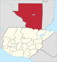
Peten is the northernmost of the 22 departments of Guatemala . With 35,854 km² it covers almost a third of the area of Guatemala and is by far the largest department in the country. Due to its territorial extent, Petén also forms one of the eight regions into which Guatemala is divided for the purposes of spatial planning and economic planning . Peten has around 760,400 inhabitants, making it the most sparsely populated department in Guatemala. It is considered the origin of the Maya . The capital of Peten is Flores .
Peten borders the Alta Verapaz and Izabal departments to the south, Mexico to the west and north and Belize to the east .
National nature

The tropical lowlands of the Petén are geologically part of the limestone plateau of the Yucatan peninsula . It is criss-crossed by several chains of hills that rarely reach heights of more than 500 m above sea level . In the far west, the Sierra del Lacandón runs parallel to the Río Usumacinta and thus to the Mexican border . To the east, it continues in the up to 300 m high Montañas Chiquibul, which form the transition to the Montañas Maya coming from Belize in the middle of the department, immediately south of Lake Petén-Itzá . The area around the city of Poptún bordering Belize is at an altitude of 450 m and thus higher than the rest of the department. In the south some foothills of the Sierra de Chamá coming from Alta Verapaz extend as far as Peten. The most important rivers are the Río Mopán in the east, the Río Azul in the northeast, the Río San Pedro in the northwest and the Río de la Pasión in the south and west. The latter flows into the Río Salinas at Pipiles, on the border with Mexico , which then flows further to the northwest as the Río Usumacinta. Vast areas along these rivers are swampy and have numerous than lagoons designated lakes . Only sporadically do they reach heights of more than 150 m above sea level. With the exception of the area east of Poptun, the climate in Petén is humid and hot. The rainy season lasts from May to December or January, which is a little longer than in the rest of Guatemala. The average annual rainfall is 1,600 mm. Temperatures usually range between 22 ° C and 29 ° C, in May they can reach 37 ° C.
At the beginning of the 20th century, Petén was almost completely covered by tropical rainforest and almost deserted. This pristine area has been home to numerous animal species , including the jaguar , puma and toucan . The later settlement and development of the department caused extensive deforestation , especially in the south, through slash and burn and thus the conversion into a savannah landscape . In the north, with the establishment of the Reserva de la Biósfera Maya biosphere reserve and some national parks , the government was able to save the rainforest and the associated fauna as far as possible. Illegal land occupations of penniless farmers and the greed for precious wood and oil represent a constant threat to the ecological balance there , which the government is not always able to ward off in view of the expansion of the nature reserves . There are now some smaller nature reserves in the south of Petén.
population
The population is concentrated on the south bank of Lake Petén-Itzá near the capital Flores in the suburbs of San Benito and Santa Elena and their surroundings, as well as along the two highways to Izabal and Alta Verapaz . Halfway there, the places Poptún and Sayaxché have gained greater importance in recent years. The other areas, especially the north, are still very sparsely populated. The few remaining descendants of the Itzá Maya live mainly around Lake Petén Itzá, the Mopan Maya near Poptún, Dolores and Santa Ana along the border with Belize, Kekchís are located in the south. In the last few decades, together with the Ladinos from all parts of the country, Maya from the highlands, especially Quiché, have settled in Petén. In 1970 about 25,000 people lived in Petén, in 2000 it was around 350,000. Today the more than 560,000 inhabitants live in a total of thirteen municipalities ( large municipalities or districts ), which in some cases extend over several thousand square kilometers and are thus more the size of departments.
| Dolores | Flores |
| La Libertad | Las Cruces |
| Melchor de Mencos | Poptun |
| San Andrés | San Benito |
| San Francisco | San Jose |
| San Luis | Santa Ana |
| Sayaxché |
The Municipios are independent regional authorities with elected mayors and representatives of the people and are subdivided into Aldeas and Pueblos (rural communities) as well as Caseríos, Parajes, Fincas, Rancherías ( hamlets and farms ). As a state administrative district , the department is headed by a governor sent by the central government .
Economy and Transport
The most important economic sectors are tourism and agriculture . Corn , beans , rice , sugar cane and tobacco are all grown . The forestry and timber industries play an important role . The extraction of chicle from the bark of chicozapote trees has been heavily regulated and is only of minor importance. Thanks to numerous Mayan ruins and nature reserves, tourism is on the rise . In the northwest, oil has been produced for several years .
Until 1982 there were no paved roads in Petén. The 500 km bus journey from Guatemala City to Flores took no less than 24 hours. The slow development of tourism began with the construction of airfields in Flores-Santa Elena , Tikal, Poptun and some other places. Because of the inadequate transport connections, Petén oriented itself more towards Mexico and Belize than Guatemala for a long time. This changed in the 1990s with the construction of the new trunk road from Río Dulce in Izabal via Poptún to Flores and on to Belize, as well as with the expansion of the connection from Alta Verapaz via Sayaxché to La Libertad and Flores. A number of unpaved secondary routes branch off from these two traffic axes to cul-de-sac villages . Near Lake Petén Itzá they already form a coherent transport network. The rest of the department is barely developed, especially in the north there are only forest roads or trails . Therefore, the rivers continue to be of considerable importance as transport routes.
history


Peten was the heartland of the Maya . Especially in the north, in pre-classical times, around 900 BC, larger, politically independent cities with monumental buildings, including Nakbé and El Mirador, 7 km south of the Mexican border, with its temple pyramids up to 70 m high . Probably originated here around 250 BC. Chr. The writing system of the Maya . After El Mirador's demise, the focus of Mayan civilization shifted somewhat to the south, particularly to Uaxactun and Tikal , which, however, soon quarreled over political heritage. Tikal won the decisive battle on January 16, 378 AD, and ruled the region for centuries. Surrounding cities repeatedly allied themselves with the aim of breaking the supremacy of Tikal, which temporarily only Calakmul (in today's Mexico) and Caracol (Belize) succeeded. During this time, the huge structures that attract so many tourists today were built in Tikal. Around 700 AD, during the heyday of the Maya, several million people lived in Peten in hundreds of towns and villages. Peten was probably one of the most densely populated areas on earth at the time. Overpopulation, wars, the exploitation of natural resources, droughts and subsequent famines and epidemics led to the decline of Mayan civilization in the early 9th century. More and more people left the big cities, especially to the northern Yucatán . When the metropolis of Chichén Itzá was destroyed there by the rival Mayapán in the 13th century , the Itzá retreated back to Peten. They settled on Lake Petén Itzá, where they built their capital, Tayasal , on a peninsula opposite today's Flores . The city was also called Taitzá ("place of the Itzá") and Noj Petén ("island town"). In addition to the Itzá, Mopan Maya lived in the east and Lacandons in the west, on the Usumacinta . The latter later withdrew to inaccessible areas of Chiapas .
In 1520, five years before the arrival of the Spanish conquistadors in Peten, the smallpox they had brought to the Yucatán had spread there and caused mass extinction among the Maya. In 1525, Hernán Cortés crossed Petén on his campaign from Mexico to Honduras . He reported small settlements in the dense rainforest and Tayasal as the only larger city. Subsequent attempts at colonization failed due to the resistance of the Itzá. It was not until 1697 that the Spanish general Martín de Ursúa succeeded in conquering Peten and Tayasal, the last independent Mayan city in Mesoamerica . Three years later, the Spaniards founded the village of Remedios del Petén (Remedios del Itzá) on an island near the south bank of Lake Petén Itzá, which received city rights in 1830 and was renamed Flores in honor of the former Vice President of Guatemala, Cirilo Flores. During the colonial period, the almost uninhabited Petén belonged to the Verapaces region, and in 1814 it became a separate administrative district as Corregimiento. After independence from Spain, General Rafael Carrera succeeded in 1840 in enforcing Guatemala's claims to Peten against Mexico. On May 8, 1866, the Guatemalan government made Peten a department. In 1882 the Herrera-Mariscal Treaty to settle border disputes with Mexico had to do without about 6,400 km² in northwest Petén. At this time, interest in Petén's Maya legacy also increased abroad. A first expedition under Modesto Méndez was followed by Carl Gustav Bernoulli , Alfred Maudslay , Teobert Maler , Alfred Tozzer and many other Maya researchers. From 1950 onwards, a number of international exploratory missions and excavations began in Petén, which Guatemala itself has increasingly carried out since around 1970.
present
On May 15, 2011, 27 or 29 bodies were found in Guatemala , in the Peten province. The Guatemalan authorities suspect the Mexican-Guatemalan drug cartel Los Zetas to be the culprit . Due to the massacre, President Alvaro Colom declared a one-day state of emergency for the Peten province on May 27, 2011. This gave the police more powers.
Attractions
To date, more than 200 archaeological sites have been found in Peten, including 80 large ceremonial centers. Few are considered tourist attractions. Some of the Peten visitors arrive at Flores Airport in the morning and drive to Tikal, 60 km to the northeast, visit the pyramids and ruins, and leave again in the evening. In addition to Tikal, there are some other less crowded Mayan ruins worth seeing, whose visit also gives a larger overview of the national nature of Petén. This includes Yaxha, 30 km southeast of Tikal, on the lake of the same name, on whose island Topoxté there is another ruin site from the post-classical period. Yaxha was discovered by Teobert Maler in 1907 and excavated and restored from 1989 with the support of the Kreditanstalt für Wiederaufbau . The sites further north such as Uaxactún, El Mirador and Nakbé can only be reached with greater effort.
In the west of the Peten, Sayaxché on the Río de la Pasión is the ideal starting point for tours to Ceibal , Aguateca and Dos Pilas . Via the Río de la Pasión you can reach the ruins of Altar de Sacrificios at its mouth in the Salinas and from there on the Río Usumacinta in a north-westerly direction Yaxchilán , Piedras Negras and finally Palenque in Mexico.
Individual evidence
- ^ A b After the massacre, an emergency in part of Guatemala. In: Neue Zürcher Zeitung . May 17, 2011, accessed May 19, 2011 .
- ^ C. Romero and T. Keppler: Massacre in Guatemala. In: the daily newspaper . May 16, 2011, accessed May 16, 2011 .
Web links
Alta Verapaz | Baja Verapaz | Chimaltenango | Chiquimula | El Progreso | Escuintla | Guatemala | Huehuetenango | Izabal | Jalapa | Jutiapa | Petén | Quetzaltenango | Quiché | Retalhuleu | Sacatepéquez | San Marcos | Santa Rosa | Sololá | Suchitepéquez | Totonicapán | Zacapa
Coordinates: 16 ° 50 ′ N , 90 ° 0 ′ W