
San Marcos Department
| San Marcos | |
|---|---|
  |
|
| Data | |
| Capital | San Marcos (Guatemala) |
| population | 1,147,400 ( ber . 2016) |
| surface | 3,791 km² |
| Population density | 303 inhabitants / km² |
| Highest elevation | Tajumulco (4,220 m) |
| ISO 3166-2 | GT-SM |
| Website | Inforpressca.com |
 |
|
 |
|
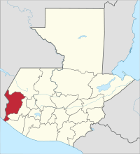
San Marcos is a department of Guatemala and is located in the southwest of the country (Region VI). San Marcos covers almost 3,800 square kilometers and has about 1,147,400 inhabitants. The capital of the department is the eponymous San Marcos .
The department of San Marcos borders in the north with the department Huehuetenango , in the east and southeast with Quetzaltenango , in the south with Retalhuleu and the Pacific and in the west with Mexico .
National nature
The department of San Marcos, located on the border with Mexico , includes almost all climatic and vegetation zones in Guatemala. Most of the department is located in the mountain ranges of the Guatemalan Sierra Madre de Chiapas , which has its highest peaks here with the volcanoes Tajumulco (4,220 m) and Tacaná (4,092 m). Only the southernmost parts lie in a narrow lowland strip, the numerous rivers of which drain large parts of the highlands and flow into the Pacific . In the mountains with an average height of over 2,000 m, temperatures in the dry season (November - February) can drop below freezing point , while the climate and vegetation on the coast are tropical.
population
In addition to Spanish , a large part of the population also speaks Mam , Tacaneco (around Tacaná) or Sipacapeno . The approximately 1,147,400 inhabitants of the department of San Marcos live in 29 municipalities ( large communities or districts ):
As a state administrative district , the department is headed by a governor sent by the central government . The Municipios are independent regional authorities with elected mayors and representatives of the people and are subdivided into Aldeas and Pueblos (rural communities) as well as Caseríos, Parajes, Fincas, Rancherías ( hamlets and farms ).
economy
Traditionally the most important economic sectors are agriculture , livestock and handicrafts . The most important agricultural products are wheat , oats , barley , potatoes , coffee , beans , corn , rice , bananas , sugar cane and cocoa . In addition, cattle and horse breeding play a special role. The products of the numerous small craft businesses include furniture , roof tiles , bricks , wicker , traditional ceramics and textiles . Trade and transit traffic with Mexico is also important . San Marcos suffers from drug and human trafficking activities because of its location on the border with Mexico and because of the important traffic routes. This applies above all to the border crossings to Mexico, while the security situation in the central areas of the highlands is relatively good, even compared to other departments. Tourism is developing slowly. San Marcos is connected to Guatemala City by the Interamericana (CA-1) running through the highlands . Via Malacatán in the west and Quetzaltenango in the east, the lowland Pacific route (CA-2) and thus the important ports in Champerico and Puerto San José can be reached. The nearest airport is in Quetzaltenango .
Attractions
Tourists coming from Guatemala City usually reach San Marcos via the well-developed, but winding, and up to 3,670 m high Interamericana . The 250 km bus journey takes no less than five hours. South of the city of San Marcos are the Balneario and the Grutas La Castalia , natural thermal baths with views of waterfalls and the mountains of San Cristóbal Cucho. North of the capital of the department is San Lorenzo, the birthplace of the first liberal president of Guatemala, Justo Rufino Barrios Auyón , with a museum dedicated to him. To the northwest, Guatemala's highest volcanoes, the Tajumulco and the Tacaná , join . On the way into the lowlands, there are rafting opportunities on the Río Naranjo . On the coast there is the nature reserve La Chorrera-Manchón Guamuchal with Playa de Tilapa , a beach that is known more for its flora and fauna than for its bathing quality. Other beaches (with dark sand) are at Ocós, Tilapa and Isla del Tular.
history
During the colonial period, the area of San Marcos belonged to Quetzaltenango . After independence from Spain , it initially belonged to the Estado de Los Altos , the so-called sixth state of the Central American Confederation . On May 8, 1849, this area officially joined the Guatemalan state. San Marcos was elevated to a department on May 8, 1866.
Web links
- Overview of the department (Spanish)
Alta Verapaz | Baja Verapaz | Chimaltenango | Chiquimula | El Progreso | Escuintla | Guatemala | Huehuetenango | Izabal | Jalapa | Jutiapa | Petén | Quetzaltenango | Quiché | Retalhuleu | Sacatepéquez | San Marcos | Santa Rosa | Sololá | Suchitepéquez | Totonicapán | Zacapa
Coordinates: 14 ° 58 ′ N , 91 ° 48 ′ W