Huehuetenango Department
| Huehuetenango | |
|---|---|
| Location of Huehuetenango in Guatemala | |
| Data | |
| Capital | Huehuetenango |
| population | 1,294,100 ( cal . 2016) |
| surface | 7,403 km² |
| Population density | 175 inhabitants / km² |
| Highest elevation | Cuchumatanes (3,837 m) |
| ISO 3166-2 | GT-HU |
| Website | Inforpressca.com |
| Coat of arms of the Huehuetenango department with the Mayan pyramid Zaculeu | |
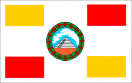
| Flag of Huehuetenango Department | |
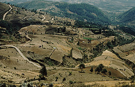
| Landscape near Todos Santos Cuchumatán (2,500 m) | |
Huehuetenango is a department of Guatemala and is located in the northwest of the country (Region VII) on the border with Mexico . It extends over 7,400 square kilometers and has about a million inhabitants. The capital of the department is Huehuetenango .
The Huehuetenango department borders Mexico to the northwest and north , the Quiché department to the east, Totonicapán and Quetzaltenango to the south, and San Marcos to the southwest .
National nature
Huehuetenango is one of the largest and highest located departments of Guatemala. It is located in the Sierra de los Cuchumatanes mountain range between 300 and over 3,800 meters, the average altitude is just under 2,000 meters. The area is cut by numerous deep valleys whose rivers Huehuetenango drain towards Chiapas and Quiché. The lowlands on the northern border with Mexico are covered by tropical rainforest . The climate can be very different depending on the location, usually it is temperate to cool, with temperatures between 9 and 22 ° C. There can be frost at high altitudes from November to February .
population
Due to the peripheral location of the department and its mountainous regions, which are often difficult to access, the linguistic diversity and the cultural identity of the indigenous population has generally been well preserved. About 85 percent of the population are direct descendants of the Maya . In addition to Spanish, nine Maya languages are spoken, of which Mam is by far the most important. The vast majority of the population lives in rural areas, where there is a lack of schools, medical care, electricity and water connections. This explains Huehuetenango's high illiteracy, birth, child mortality and poverty rates. The department is divided into 32 municipalities ( large municipalities or districts ):
As a state administrative district , the department is headed by a governor sent by the central government . The Municipios are independent regional authorities with elected mayors and representatives of the people and are subdivided into Aldeas (rural communities) and Caseríos, Parajes or Fincas ( hamlets and farms ).
economy
The most important industry in Huehuetenango is agriculture . Domestic sheep breeding plays a special role in the higher elevations , and potatoes , maize , oats , wheat and broad beans are mainly grown here. In the lower-lying areas in the west, coffee cultivation is important, in the jungle areas in the northeast there are banana and sugar cane plantations . The infrastructure necessary for increasing tourism is missing and only a few business people profit financially from the numerous short visits to the city of Huehuetenango, Zaculeu and Todos Santos Cuchumatán and the surrounding area, while at the same time the cultural self-image of the local rural population is increasingly losing its basis. In this context, periodically returning emigrants and the products and habits they bring with them also play a role.
Due to its location and nature, the department has insufficient transport links. Coming from Mexico, the Interamericana runs through the department in the southwest and connects its capital Huehuetenango with Quetzaltenango and the rest of the country. At the capital Huehuetenango a winding country road branches off, which connects the department via Aguacatán with Quiché and Alta Verapaz . Huehuetenango hardly benefits economically from this poorly developed connection. However, a large east-west transversal is planned. The capital Huehuetenango has a small airfield for general aviation .
Attractions

The capital Huehuetenango is usually the starting point for excursions in the department. The city itself has a small city park, around which public buildings are well worth seeing, and a market of national importance. 5 km west of the capital is the former Mayan fortress Zaculeu with a museum. Further evidence of Mayan culture can be found in Aguacatán (Chalchitán and sources of the Río San Juan), Chiantla Vieja and Tecpán on the Interamericana . The mountain range of the Sierra de Los Cuchumatanes rises north of the city of Huehuetenango. In Chiantla, the former Talbín , the Dominicans built an impressive monastery complex between 1530 and 1564 . From 1723 the Mercedarians built what is now the pilgrimage church of Nuestra Señora de Candelaria . From Chiantla you can reach the Mirador Juan Diéguez Olaverri viewpoint, which is around 3,000 m high . To the northwest is Todos Santos Cuchumatán, a remote Mam village that attracts many tourists because of the traditional costumes of its inhabitants and its beautiful location. Horse races are held here on November 1st and January 1st. In neighboring Tojcunanchén keep shamans from ancient ceremonies.
Further north of the department, where you can understand the traditional way of life of the Maya descendants, is San Rafael La Independencia with the Xetaj, which is interesting for mountaineers, and the Yulajá and Villa Linda rivers. At Barillas, which is already in the tropical lowlands, there are several caves worth seeing. In the far north, on the border with Mexico, lies the Laguna Yolnajab, a five kilometer long lake, and El Cimarrón, a 200 m deep crater with a diameter of 200 m, on the bottom of which trees grow.
history
Even before the arrival of the Spaniards, the area of Huehuetenango was the scene of fierce fighting between the Chiapas-born Mam and the Quiché , which together with the Cakchiquel were finally able to prevail. The Mam avoided San Marcos and the area around today's city of Huehuetenango , where they built their fortress and ceremonial center near Zaculeu . In 1525 the Spaniards under Gonzalo de Alvarado advanced as far as Zaculeu after they had beaten 5,000 Mam at Malacatancito from the south. The fortress of Zaculeu withstood the attacks of the Spanish troops for four months, then the Mam king Kaibil Balam and his starved and decimated fortress crew had to give up and flee to the surrounding mountains. Centuries later, the Guatemalan armed forces named their special forces, the Kaibiles , after the defender of Zaculeu. In the 1970s and 1980s, the Guatemalan civil war in particular suffered from indigenous people in the departments of Huehuetenango and Quiché. Kaibiles committed several war crimes here.
During the colonial period, the area of Huehuetenango belonged to Totonicapán , after independence it was part of the Estado de Los Altos , the so-called sixth state of the Central American Confederation, from 1838 to 1840 . On May 8, 1849, this area officially joined the Guatemalan state. Huehuetenango was elevated to the department on May 8, 1866. The origin of the name Huehuetenango is not clear, but it is likely to go back to corruptions of the Mayan names Xinabajul ("between the gorges") and Ahuehuetlenango ("place of the ancients").
Web links
- Overview of the department (Spanish)
Coordinates: 15 ° 19 ′ N , 91 ° 28 ′ W


