
Retalhuleu Department
| Retalhuleu | |
|---|---|
  |
|
| Data | |
| Capital | Retalhuleu |
| population | 340,100 calculation 2016 |
| surface | 1,856 km² |
| Population density | 183 inhabitants / km² |
| structure | 9 |
| ISO 3166-2 | GT-RE |
| Website | Inforpressca.com |
 |
|
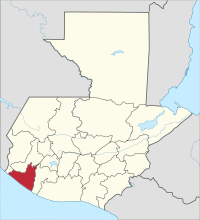
Retalhuleu is one of 22 departments in Guatemala and is located in the south-west of the country on the Pacific (Region VI). It extends over 1,856 km² and has just under 340,100 inhabitants. The capital is the city of the same name Retalhuleu .
The Departamento Retalhuleu (often called "Re-u" for short) borders in the north on the Departamento Quetzaltenango , in the east on Suchitepéquez , in the south and southwest on the Pacific , in the west on San Marcos .
National nature
Retalhuleu only has a small part of the Sierra Madre in the very north , the majority is in the lowlands gently sloping to the southwest towards the Pacific coast. In this direction it is also crossed by several rivers, of which the Río Samalá is the most important. The very fertile volcanic soils of the lowlands produce lush tropical vegetation , but most of this has to give way to agriculture. The black sand beaches, behind which there are large swamps, are of volcanic origin . The marshes of Manchón in the far west, with their mangrove forests criss-crossed by a number of rivers and canals , which offer refuge for water birds and turtles , have been placed under nature protection. The marshland near El Tulate can practically only be reached via the neighboring Suchitepéquez.
With the exception of a few smaller temperate areas in the north, the climate in Retalhuleu is tropically hot, and during the rainy season (May to October) there is also high humidity . The temperatures are generally between 20 and 32 ° C.
population
The population is concentrated in the north of the department. In addition to the Spanish colonial language , the Maya language Quiché is still spoken today - mainly in the communities of San Andrés Villa Seca, San Felipe Retalhuleu, San Martín Zapotitlán, San Sebastián and Santa Cruz Muluá . The approximately 285,000 inhabitants of the department live in a total of nine municipalities ( large municipalities or districts ):
| Champerico | El Asintal |
| Nuevo San Carlos | Retalhuleu |
| San Andrés Villa Seca | San Martín Zapotitlán |
| San Felipe | San Sebastian |
| Santa Cruz Muluá |
As a state administrative district , the department is headed by a governor sent by the central government . The Municipios are independent regional authorities with elected mayors and representatives of the people and are subdivided into Aldeas and Pueblos (rural communities) as well as Caseríos, Parajes, Fincas, Rancherías ( hamlets and farms ).
Economy and Transport
Retalhuleu is one of the most important economic regions in Guatemala today. Due to the very fertile soil, agriculture is traditionally the strongest branch of the economy. After the end of the coffee boom , the large landowners switched most of their production to sugar cane . Bananas , corn , beans and other types of fruit and vegetables, as well as animal husbandry, are only of secondary importance. For the processing of agricultural products, especially sugar cane, a number of industrial companies have settled around the capital. Crafts and the service sector also make a major contribution to the relative prosperity of the department.
Due to its location at the crossroads of important traffic routes, Retalhuleu in the western Pacific lowlands occupies an economically similar position as Escuintla in the east. North of the capital Retalhuleu meeting of Mexico and El Salvador next highway CA 2 and Quetzaltenango in the highlands with Champerico on the Pacific connecting National Highway 9. The more or less parallel to these highways Railroads have been shut down a long time ago and partly dismantled. In the past, they were mainly used to transport agricultural products, just like the former port of Champerico, whose facilities were destroyed by a storm in 1982. The suspension of rail traffic has led to a chronic congestion of the trunk roads with heavy traffic. This has been partially counteracted in recent years by expanding the Pacific trunk road to four lanes. The rest of the road network is only well developed in the north and in the middle. The town of Retalhuleu has an airfield for general aviation .
The tourism benefits from a few sites such as the Mayan ruins of Takalik Abaj and San Juan Noj , but especially from through traffic. Many travelers from Guatemala City to Quetzaltenango prefer the well-developed routes in the lowlands to the winding Interamericana in the highlands. The Xocomil water park and the Xetulul theme park run by the IRTRA charity are of national tourist importance. The facilities are located at San Martín Zapotitlán on the road to Quetzaltenango.
history
Even in the pre-classical period , the area of today's department benefited from trade between the highlands and the coast. In Takalik Abaj and other trading centers, Olmecs met Maya who shaped the area equally. At the time of the Spanish conquest , the area of Retalhuleu was disputed between the rival Mam and Quiché . The Conquistador Pedro de Alvarado is said to have drawn a boundary line in the ground between the two warring parties with the sword at Retalhuleu. The name of the city and the department, which means something like "signs on the ground", is derived from this incident. During the colonial period, Retalhuleu and Suchitepéquez formed the Corregimiento de Suchitepéquez administrative district . After independence from Spain, between 1838 and 1849, this area repeatedly belonged to the Estado de Los Altos , the so-called sixth state of the Central American Confederation . The administrative district Suchitepéquez was divided into the two today's departments on October 16, 1877.
Web links
Individual evidence
- ↑ "Site indicates early Mayan writing" in: n-tv.de of March 11, 2020
Alta Verapaz | Baja Verapaz | Chimaltenango | Chiquimula | El Progreso | Escuintla | Guatemala | Huehuetenango | Izabal | Jalapa | Jutiapa | Petén | Quetzaltenango | Quiché | Retalhuleu | Sacatepéquez | San Marcos | Santa Rosa | Sololá | Suchitepéquez | Totonicapán | Zacapa
Coordinates: 14 ° 22 ′ N , 91 ° 45 ′ W