
Sacatepéquez Department
| Sacatepéquez | |
|---|---|
  |
|
| Data | |
| Capital | Antigua Guatemala |
| population | 349,900 ( ber . 2016) |
| surface | 465 km² |
| Population density | 753 inhabitants / km² |
| Highest elevation | Acatenango (3,975 m) |
| ISO 3166-2 | GT-SA |
| Website | Inforpressca.com |
 |
|
 |
|
 |
|
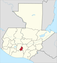
Sacatepéquez is the smallest department of Guatemala and is located in the middle of the country (Region V). It covers 465 square kilometers and has about 349,900 inhabitants. The capital of the department is Antigua Guatemala .
Sacatepéquez borders the Department of Guatemala to the north and east , Escuintla to the south and Chimaltenango to the west .
National nature
Sacatepéquez is located in the central highlands at an average altitude of 1,530 meters. On the southern border of the department are three of the highest volcanoes in Guatemala, the Volcán de Agua (3,765 m), the Volcán de Fuego (3,763 m) and the Volcán Acatenango (3,975 m). The climate is temperate, temperatures are between 13 and 25 ° C. Sacatepéquez has extensive forest areas.
population
A large part of the population speaks Spanish and Cakchiquel . The approximately 349,900 inhabitants of the department of San Marcos live in 16 municipalities ( large communities or districts ):
As a state administrative district , the department is headed by a governor sent by the central government . The Municipios are independent regional authorities with elected mayors and representatives of the people and are subdivided into Aldeas (rural communities) and Caseríos, Parajes or Fincas ( hamlets and farms ).
economy
Traditionally the most important economic sectors are agriculture , livestock and handicrafts . The main agricultural products are coffee , cereals , beans , corn and ornamental plants . In addition, cattle and horse breeding plays a role. The products of the numerous small handicraft businesses include furniture , leather and wicker goods , traditional ceramics and textiles as well as goldsmith items . The tourism is well developed due to the numerous attractions.
Attractions
One of the main attractions of Guatemala is 45 km away from Guatemala City away Antigua Guatemala , a small town that since 1979 the World Heritage matters. In 1543 she became the successor to Ciudad Vieja, a few kilometers southwest, as the capital of Central America. After Antigua was destroyed by a severe earthquake in 1773, the capital was moved to Guatemala City. Antigua's restored colonial cityscape with the cathedral and the seat of government of the captains general is one of the most beautiful in Guatemala. From Antigua, climbers reach the 3,765 m high Volcán de Agua via Santa María de Jesús , which buried the old capital Ciudad Vieja under water and mud in 1541. The other two volcanoes, Acatenango and Fuego, can be reached from Antigua on the road that leads via Ciudad Vieja and Alotenango to Escuintla and on to the Pacific. Between Santa Lucía Milpas Altas and Magdalena Milpas Altas is the Parque Ecológico Florencia with its untouched forests. Further north from San Lucas Sacatepéquez (Mirador San Lucas) you have an excellent view of Guatemala City. At Jocotenango there is a special sanctuary for a total of 23 species of butterflies . In San Juan Obispo you can visit the baroque residence of the first bishop of Guatemala, Francisco Marroquín . Marroquín had campaigned for the indigenous population and founded the Colegio Mayor de Santo Tomás in 1562, from which today's Universidad San Carlos de Guatemala emerged.
history
Antigua Guatemala was the political center of Central America within the viceroyalty of New Spain during colonial times . The wider area of Antigua Guatemala formed a province in 1752 ( Alcaldía Mayor de Sacatepéquez , in other cases called Corregimiento or Gobernación ). Today's Sacatepéquez Department was founded on September 12, 1839 after independence from Spain .
The name Sacatepéquez comes from the dialect of the Pipil Maya and means grass hill . A village founded in 1542 bore this name until it was destroyed on July 29, 1773.
Web links
- Overview of the department (Spanish)
Alta Verapaz | Baja Verapaz | Chimaltenango | Chiquimula | El Progreso | Escuintla | Guatemala | Huehuetenango | Izabal | Jalapa | Jutiapa | Petén | Quetzaltenango | Quiché | Retalhuleu | Sacatepéquez | San Marcos | Santa Rosa | Sololá | Suchitepéquez | Totonicapán | Zacapa
Coordinates: 14 ° 33 ′ N , 90 ° 44 ′ W