Escuintla Department
| Escuintla | |
|---|---|
| Location of Escuintla in Guatemala | |
| Data | |
| Capital | Escuintla (Guatemala) |
| population | 775,700 ( ber . 2016) |
| surface | 4,384 km² |
| Population density | 177 people / km² |
| Other cities | 1 |
| Highest elevation | Volcán de Agua (3,766 m) |
| ISO 3166-2 | GT-ES |
| Website | Inforpressca.com |
| Coat of arms of the Escuintla department | |
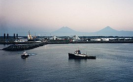
| View from Puerto Quetzal to the volcanoes of the highlands in the north | |
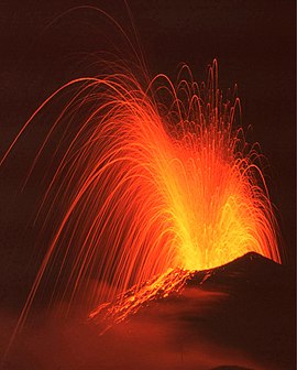
| Pacaya volcano. The northern border of the department runs along the most important volcanoes in the region. | |
Escuintla is a department of Guatemala and is located in the south of the country (Region V). It covers over 4,300 square kilometers and has about 775,700 inhabitants. The capital of the department is the Escuintla of the same name .
The Escuintla department is bordered by the Chimaltenango , Sacatepéquez and Guatemala departments to the north, Santa Rosa to the east, the Pacific Ocean to the south and Suchitepéquez to the west and northwest .
National nature
The northern borders of the department run over the highest peaks of the central highlands, including the volcanoes Agua (3,766 m), Fuego (3,763 m) and Pacaya (2,552 m). From these mountains the land, which is crossed by numerous rivers, slopes gently south to the Pacific coast. The soil is very fertile. Due to the heavy agricultural use, the originally diverse population of wild animals has declined. The climate is tropical hot, the rainy season lasts from May to October.
population
The original indigenous population mixed heavily with Spaniards during the colonial period. Mayan languages are no longer spoken except in Palín ( Pocomam ) and Santa Lucía Cotzumalguapa ( Cakchiquel ). The population is distributed relatively evenly over the entire area of the department, there are concentrations along the most important transport links, the Carretera Interoceanica (CA-9) and the CA-2, which runs in the lowlands from Mexico to El Salvador . Escuintla is divided into 13 Municipios ( large municipalities or districts ):
| Escuintla | Santa Lucía Cotzumalguapa |
| La Democracia | Siquinalá |
| Masagua | Pueblo Nuevo Tiquisate |
| La Gomera | Guanagazapa |
| Puerto San José | Iztapa |
| Palin | San Vicente Pacaya |
| Nueva Concepción |
As a state administrative district , the department is headed by a governor sent by the central government . The Municipios are independent regional authorities with elected mayors and representatives of the people and are subdivided into Aldeas (rural communities) and Caseríos, Parajes or Fincas ( hamlets and farms ).
economy
Escuintla is the richest department in Guatemala. This is where 43 percent of Guatemala's gross domestic product is generated. Traditionally the most important branch of the economy is agriculture, which is diverse due to the fertile soil and the different altitudes. The numerous large fincas mainly produce sugar cane , corn , beans , bananas , coffee , cotton and various citrus fruits . The Pacific ports are of particular importance. Puerto San José was for a long time Guatemala's gateway to the Pacific, later the neighboring modern industrial port of Puerto Quetzal took over this role. Fishing and tourism are also important on the coast . Modern hotel complexes emerged mainly near Chulamar, Likín and Iztapa, but this has led to the fact that there are hardly any public access to the beaches. The many small craft businesses also contribute to the relative prosperity of the department. Escuintla has the lowest unemployment and poverty rates in Guatemala.
The department is well developed in terms of transport. The two important port cities are connected to Guatemala City via a modern motorway (CA-9) , which is crossed by the CA-2 lowland route at the departmental capital Escuintla. There is also a railway line from Puerto Quetzal to Guatemala City, which was recently only used for freight traffic. The cities of Escuintla and Puerto San José have airports of regional importance.
Attractions
Many wealthy Guatemala City citizens have vacation homes on the coast of Escuintla . Domestic and foreign tourists like to use the various holiday resorts around Puerto San José or drive to the lagoons of Iztapa or further east to the beaches of El Conacaste. The well-known tourist town of Monterrico is located in the neighboring department of Santa Rosa , but can be reached via Iztapa. The beaches of San José Rama Blanca, La Empalizada, El Paredón Buena Vista and Parque Nacional Sipacate in the central coastal section can only be reached via La Gomera, in the west there are beaches at Tecojate and El Semillero with the one for them Guatemalan Pacific coast so typical dark sand.
There are still various testimonies of the Maya era in the interior of the country. In the central park of La Democracia there is a collection of large stone heads from the Monte Alto culture . North of Santa Lucía Cotzumalguapa is El Baúl , the center of the Cotzumalguapa culture with an acropolis and over 70 statues, including Monument 14 ("El Tigre"), which is considered a masterpiece of this culture. Further archaeological evidence of the Mayan civilization was discovered in Betancourt and Sin Cabezas in the Municipio Pueblo Nuevo Tiquisate, Ixtepeque (Nueva Concepción), La Selva (La Gomera) and Balberta (El Pilar, La Democracia).
On the road to El Salvador (CA-2) there are numerous animals to be seen near Brito in the nature reserve and adventure park “Autosafari Chapín”. In the mountains, the still active Pacaya volcano is the biggest tourist attraction.
history
The area of Escuintla was conquered in the 16th century by Pedro de Alvarado , who built Guatemala's first Pacific port a few kilometers east of today's port of Puerto Quetzal, near Iztapa. This port was connected to Ciudad Vieja and Antigua Guatemala by a road that still exists today , where the administrative seat of the Spanish colonial rule in Central America was at that time. The city of Escuintla was already the seat of a district administration in colonial times. After independence, the National Assembly established the Escuintla Department on November 4, 1825. The name comes from the Mayan expression "Izcuintlán" or from the Pipil settlement Iscuintepéque ("Yxcuyntepeque"). The expressions mean something like “place” or “hill of dogs” and probably refer to the Tepescuintles , a dog-sized rodent that was popular in pre-Columbian times .
Web links
- Overview of the department (Spanish)
Coordinates: 14 ° 18 ′ N , 90 ° 47 ′ W


