La Libertad (Peten)
| La Libertad | ||
|---|---|---|
|
Coordinates: 16 ° 47 ′ N , 90 ° 7 ′ W La Libertad on the map of Guatemala
|
||
| Basic data | ||
| Country | Guatemala | |
| Department | Peten | |
| City foundation | 1795 | |
| Residents | 35,000 | |
| - in the metropolitan area | 7,000 | |
| Detailed data | ||
| surface | 5272 km 2 | |
| Population density | 7 people / km 2 | |
| height | 190 m | |
| Waters | numerous | |
| Post Code | 17005 | |
| Time zone | UTC −6 | |
| City patron | Virgen de Guadalupe (festival: December 3rd to 12th) | |
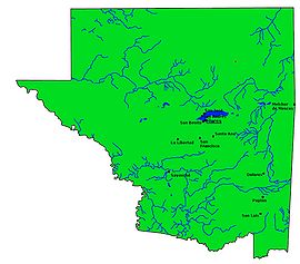
| Peténs map | ||
La Libertad is a small town in Guatemala with a population of over 7,000 . La Libertad is located in the Department of Petén and is the administrative seat of a municipality that extends over 5,271 km² and has over 35,000 inhabitants. At the end of 2011, La Libertad lost a large part of its administrative area, as the former rural community ( aldea ) Las Cruces was elevated to a municipality.
geography
The place La Libertad is located around 30 km southwest of Lake Petén-Itzá at an altitude of 190 m. From Flores , the lakeside capital of the Petén department, the national road 5 leads via La Libertad and Sayaxché to Alta Verapaz further south . La Libertad forms the south-western boundary of a somewhat more densely populated region south of Lake Petén-Itzá, which has a relatively close-knit network of secondary routes. This also connects La Libertad with the CA 13 road, which leads to Izabal in the eastern part of Petén . After Guatemala City there are km on 500th
As with all Municipios Peténs, the main town is located on a major traffic axis, while the administrative area extends far into the back, sparsely populated regions. With 7,047 km², La Libertad was not only one of the largest municipalities in Guatemala until 2011, but also larger than 17 of the country's 22 departments in terms of area. It comprised the western lowlands of Petén, bounded by the Río San Pedro in the north, the Río Usumacinta in the west and the Río de la Pasión in the south. La Libertad lost a 1,775,264 square kilometer stretch of land along the Río Usumacinta at the end of 2011 when the rural community of Las Cruces was elevated to an independent municipality. This leaves around 5,272 square kilometers of the somewhat better developed lowland area near La Libertad. In the north-west, the up to 672 m high Sierra del Lacandón ( National Park ) runs in a south-easterly direction , its hilly foothills (Montañas Chiquibul) occupying the center and east of the municipality. This area, which still belongs to the municipality of La Libertad, is largely still covered by tropical rainforest . The climate is hot and humid.
The neighboring municipalities are San Andrés in the north, San Benito and San Francisco in the east, Sayaxché in the south and Las Cruces in the southwest and west. Many hamlets and rural settlements in the northwest of the municipality can only be reached from the national road 13, which runs there, via gravel roads and beaten paths.
history
The train was conquered by the Spanish conquistadors who fled Lacandon from Yucatán to the then largely uninhabited land on the Usumacinta, Itzá could be (again) on Lake Petén Itzá down. In the course of time, Kekchí moved from the south and then next to Spaniards and Ladinos also highland Maya . Today's La Libertad was also founded by immigrants from Yucatán, initially as Finca Sacluk . In 1795 the village was named Guadalupe Sacluk . On February 7, 1880, it was renamed La Libertad and made the capital of Peten, a status that it lost to Flores on October 24, 1882 due to the inadequate infrastructure. Around 1880 the municipality had around 1,500 inhabitants, a third of whom lived in the main town. In the years that followed, a number of ranchers immigrated from Chiapas, Mexico . In 1926, an airplane landed in La Libertad and thus for the first time in Petén.
population
Today two thirds of the population consists of Ladinos, the rest of the population are Maya of various ethnic groups. In the last few decades the population has increased significantly. Around 40,000 people are currently likely to live in the municipality of La Libertad, over 80 percent of them in rural areas.
economy
La Libertad lives mainly from agriculture, especially from growing maize and beans as well as from cattle breeding . Oil is produced in the area . At La Libertad there is a small oil refinery and an airfield for general aviation . Because of the charming landscape and the rich Mayan cultural heritage, tourism also plays a role.
See also
Web links
- Data on inforpressca.com (Spanish)
- Extensive information on elportaldepeten.com (Spanish)

