Yucatán (peninsula)
| Yucatan | |
 Satellite image of the Yucatan Peninsula |
|
| Geographical location | |
| Coordinates | 18 ° 50 '42 " N , 89 ° 7' 32" W |
| Waters 1 | Caribbean Sea |
| Waters 2 | Gulf of Mexico |
Yucatán (in Mayathan earlier Yucal Peten , also Mayab "land of the Maya"), German also Yucatan , is a peninsula in North America that separates the Gulf of Mexico from the Caribbean Sea . The northern part belongs politically to Mexico , divided into the three states of Yucatán , Campeche and Quintana Roo . The south belongs to Guatemala and Belize . Off the eastern coast of the peninsula is Cozumel , the third largest island in Mexico.
The climate is tropical and hot. In the humid south, rainforests make up a large part of the vegetation . Dense forest dominates the central part. Except for a few hills in the south, the area is very flat. In the limestone soil are often water-filled dips ( cenotes to find). The climate becomes drier towards the north. Yucatán is at risk of hurricanes .
etymology
One common name explanation is an alleged misunderstanding between newly arrived Spaniards and native Maya. The Spaniards asked what this country was called, and the Maya replied: Yuk ak katán (or Ma 'k u'uyik a t'àani' ), which means: "I don't understand your language". (See also the name of the kangaroo ).
Also Nahuatl is used as the language of origin of the name, as in this language -tlan is a common place name broadcast. Yuhcatla is translated as "abandoned place" in Simeon's dictionary of the Nahuatl language. Molinia translates yuc as "belonging to the others". But it could also be a loan word that refers to the yucca plant. Others attribute Yucatán to the Nahuatl word Yokatlān , which means "place of wealth".
In Chilam Balam the name Yucal Peten is mentioned for today's Yucatán. The meaning of the name can be explained with u (collar), cal ("neck") and peten (island, province, region, cf. Petén , from pet "round"), so Yucal Peten "neck region" or "neck." -Island ”in the sense of“ peninsula ”. However, it is unclear whether the Spanish name Yucatán has the same origin. In Yucal Petén it can also be a Maya - etymology of the name used by the Spanish Yucatán act.
Natural space
climate
The average proportion of rainy days per month varies from 7 percent in April to 25 percent in October. Breezes can have a cooling effect; the humidity is generally high, especially in the rainforests. Violent storms can occur all year round. Although these storms bring heavy rain and winds, they are mostly short-lived and the storm flattens out after about an hour.
Like most of the Caribbean, the Yucatán is located in the Atlantic Hurricane Belt, and the peninsula is at risk due to the flatness of the land. The 2005 Atlantic hurricane season had a negative impact on tourism with two level 5 hurricanes, Hurricane Emily and Hurricane Wilma. The 2006 Atlantic hurricane season was typical with the Yucatán unscathed, but Hurricane Dean crossed the peninsula in the following hurricane season. However, there was comparatively minor damage, which amounted to a large flood.
vegetation
Tropical jungles are the predominant vegetation of the Yucatán. The largest contiguous areas of tropical rainforest in Central America are located on the borders with northern Guatemala (El Peten), Mexico (Campeche and Quintana Roo) and western Belize. However, these forests are at risk from extensive deforestation. In the north-west, the annual precipitation decreases sharply, the vegetation is dry forest (ignoring the cultivation) and in the far north-west a savannah and steppe-like landscape.
Water resources
Because of the extremely barren landscape, there are no rivers in the northern part of the peninsula. In places where there are lakes and swamps, the water is muddy and inedible. Since the Yucatán is a peninsula, its entire underside is covered by a continuous, dense groundwater-bearing layer, the freshwater lens. Fresh water is lighter than salt water, which is why it is located above the salty layer. The thousands of limestone holes , the cenotes , which are spread throughout the region, provide access to the groundwater and the Maya also use the fresh water available in the cenotes then as now.
geology
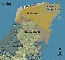
The peninsula represents the open part of the actually larger land mass of Yucatán, which consists of carbonate , i.e. soluble rocks such as limestone and in some areas of dolomite and evaporite . The total area of the Yucatán Peninsula is an exposed, flat and karstified landscape. The shaft-like limestone holes typical of the peninsula are called cenotes and are particularly widespread in the northern flatlands.
According to the Alvarez hypothesis, the extinction of the dinosaurs between the transition from the Cretaceous to the Paleogene 65 million years ago was caused by an asteroid impact in the Caribbean Sea ( KT impact ). The low-lying Chicxulub crater on the north coast is near the town of Chicxulub. The “cenote ring” known today limits one of the shock waves from this impact into the rock, which is around 65 million years old.
history
From the 4th to 10th centuries, the Yucatán was the center of the indigenous Maya culture, which left countless archaeological sites . The best known are Chichén Itzá , Uxmal , Tulum and Edzná .
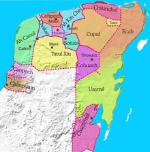
From the 12th century a breakdown into several independent political units emerged, some of which were feuding with one another (see Cuchcabal ).
Europe's influence on the region began between 1517 and 1518. Francisco Hernández de Córdoba first reached the coast at Cabo Catoche in 1517 , followed by Juan de Grijalva in 1518. The conquest of Yucatán began in 1527 with Francisco de Montejo the Elder. Ä. , which opened its capital in Tho, today's Mérida , which had come under Spanish control in 1542, but did not come to an end until 1547. The administration of this area often changed between New Spain (today's Mexico) and Guatemala until it joined the new state of Mexico in 1822.
In the 1840s, the independent state of the Republic of Yucatán existed on the peninsula . In 1847 the " caste war " ( Guerra de Castas ) broke out. The Mayan indigenous population rose, which in 1848 resulted in the Spanish Creole population in Yucatán being largely displaced. Only the fortified cities of Mérida and Campeche were spared . The government of Yucatán sent a request for help to the Mexican president and agreed to reunite with Mexico in return.
In the years that followed, there were repeated minor and major military clashes between the Yucatan government and the rebellious Mayans. It was not until 1901 that the Mexican army captured the main Maya base at Chan Santa Cruz . However, individual Mayan groups continued the fight into the 1930s.
In 1857 the western part of the state of Yucatán was separated and organized as a separate state of Campeche . In 1902, in connection with the fight against the insurgent Maya, Quintana Roo was separated as centrally administered territory; it was only raised to the rank of state in 1974.
Residents
Yucatán consists to a large extent of the former Maya lowlands (although the Maya culture also spread southwards, to today's Guatemala, to Honduras and the highlands of Chiapas). There are Maya archaeological sites all over the peninsula, the most famous of which are Chichén Itzá , Tulum and Uxmal . The indigenous Mayan tribes and the Mestizo as a Mayan lineage still form a significant proportion of the population in the region, and Mayathan is still spoken in many areas.
economy
In the late historical and early modern years, the local economy consisted of cattle raising, logging, and the production of chicle and henequen . Since the decline in the chicle and henequen trade in the 1970s, the Yucatans began to reorient their economy towards tourism. This is particularly evident in the Mexican state of Quintana Roo .
Cancún , formerly a small fishing village in the northeast of the peninsula, is now developing economically. The Riviera Maya stretches along the east coast between Cancun and Tulum . Millions of tourists come to this area every year. The most famous sights here are for example the former fishing town of Playa del Carmen , the city of Campeche , the amusement parks Xcaret and Xel-Há and the ruins of the Maya Tulum and Cobá .
See also
literature
- Harald Moßbrucker: Agricultural crisis, urbanization and tourism boom in Yucatan, Mexico. Lit, Münster 1994, ISBN 3-8258-2336-9 .


