Xel Ha
Coordinates: 20 ° 27 ′ 0 ″ N , 87 ° 18 ′ 0 ″ W.
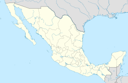
Xel Há is a Maya ruin site in the Mexican state of Quintana Roo on the east side of the Yucatán Peninsula on the Caribbean coast.
geography
The ruins of Xel Há are located about 15 km northeast of Tulum directly on Carretera 307 , the connection road between the tourist centers of Cancun and Playa del Carmen in the north and the state capital Chetumal on the border with Belize . Xel Há belongs to the municipality of Tulum, which was founded in 2008 .
The pre-Hispanic settlement consists of two areas, a roughly 1 km inland settlement with residential and cult buildings and the port facilities on the coast. The two parts were connected by a sacbé .
history
In Xel Ha there were probably two periods when the city was of greater importance. In between there was a period of stagnation, characterized by the sharp decline in construction activity.
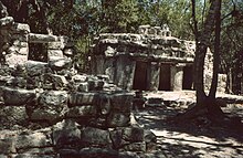
In the period from 100 to 600 AD, Xel Há developed into what is probably the most populous settlement on the surrounding coast. From this period palace-like buildings have been preserved, such as the House of Birds . Style features suggest a connection to central Mexico and especially Teotihuacan .
As a port and local coastal center, Xel Há was probably closely related to important inland cities, especially the neighboring Cobá . Various researchers assume that Xel Há together with Xcaret , Tancah and Muyil acted as ports for Coba, through which a flourishing trade with the cities further south in today's Belize and as far as Honduras ran. There is said to have been a sacbé between Xel Há and Cobá.
From around 1200 AD, Xel Há developed again into a prosperous port and trading point as part of the dwindling influence of Cobá. Xel Há was part of the coastal trade network, which ran along the Caribbean coast with a large number of locations and promoted the region economically. This shows the erection of numerous residential and cult buildings as well as a wall between the buildings near the coast and the port facilities. Similar to Xcaret, this wall was most likely a protective wall against attacks from the sea. Some researchers see this as a feature of the unsafe living conditions that prevailed in the Caribbean coastal region at the time.
After the arrival of the Spaniards on this stretch of coast, the place gradually became depopulated. The residents sought refuge in the southern areas of the Yucatán Peninsula that had not been conquered by the Spanish. The site was deserted in the middle of the 16th century.
In the 1980s, a water park of the same name opened in Xel Há, which is now very popular with tourists. The world's largest natural aquarium is nestled in a nature reserve . Numerous activities such as snorkeling, diving, dolphin swimming and kayaking are offered.
See also
Individual evidence
- ↑ ZONA ARQUEOLÓGICA DE MUYIL
- ↑ The Mayan site of Muyil on the east coast of the Yucatán Peninsula in Mexico
- ↑ INAH Archaeological Site Xel Há> Historia ( Memento from February 20, 2008 in the Internet Archive )
- ↑ Xelhá - Mayan port city ( Memento from March 11, 2011 in the Internet Archive )
Web links
- Main page of the INAH Instituto Nacional de Antropología e Historia (Spanish).
- Photos by Xel Há ( memento from March 11, 2011 in the Internet Archive ) on Rudi Oeser's private homepage, Mesoamerica, accessed on September 10, 2009 (German).
- Website of the theme park Xel-Há (English)


