
Palaststrasse (Trier)
| Palaststrasse | |
|---|---|
|
|
|
 |
|
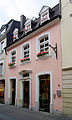
| Guild House in Palaststrasse 12 | |
| Basic data | |
| place | trier |
| District | center |
| Connecting roads | Grabenstrasse , Konstantinstrasse |
| Cross streets | At the Breitenstein |
The Palace Street is a street in the Trier city center . It runs from Grabenstrasse to Konstantinstrasse. Its name is derived from this tour, as the Constantine Basilica is located in the immediate vicinity , which was converted into the Electoral Palace in the Middle Ages .
In the street there are a total of six cultural monuments from different epochs. The guild house of Joseph Mendgen in Palaststrasse 12 even dates from the year 1400. The baroque town hall at number 7, which was destroyed in the Second World War , used to be among the cultural monuments .
At the upper end of Palaststrasse is the northeast exit of the Trier C&A branch, the new building of which was opened on Konstantinstrasse in 1969.
Palaststrasse 19: richly profiled skylight portal, marked 1736, architect Lorenz Pauli

literature
- Patrick Ostermann (arrangement): Cultural monuments in Rhineland-Palatinate. Monument topography Federal Republic of Germany. Volume 17.1: City of Trier. Old town. Werner, Worms 2001, ISBN 3-88462-171-8
- Ulrike Weber (edit.): Cultural monuments in Rhineland-Palatinate. Monument topography Federal Republic of Germany. Volume 17.2: City of Trier. City expansion and districts. Werner, Worms 2009, ISBN 978-3-88462-275-9 .
- General Directorate for Cultural Heritage Rhineland-Palatinate (publisher): Informational directory of cultural monuments of the district-free city of Trier. (PDF; 1.2 MB) Koblenz 2010.
- Kulturbüro der Stadt Trier (ed.) / Emil Zenz: Street names of the city of Trier: their sense and their meaning. Trier 2003.
Individual evidence
- ↑ Kulturbüro der Stadt Trier (ed.) / Emil Zenz: Street names of the city of Trier: their sense and their meaning. Trier, 2003.
- ^ Patrick Ostermann (arrangement): Cultural monuments in Rhineland-Palatinate. Monument topography Federal Republic of Germany. Volume 17.1: City of Trier. Altstadt.Werner, Worms 2001
- ↑ Helmut Lutz: Directory of the listed buildings since 1930. Preservation of monuments in Trier (1975) Ed .: Urban preservation of monuments
- ↑ Mutti Krause is unforgotten , www.volksfreund.de, October 5, 2016; accessed August 25, 2020
Coordinates: 49 ° 45 ′ 18.3 " N , 6 ° 38 ′ 29.3" E