Palinuro (volcano)
| Palinuro | ||
|---|---|---|
|
Aeolian Arch, Palinuro on the map to the northeast |
||
| height | 70 m below sea level | |
| location | Italy | |
| Coordinates | 39 ° 59 '12 " N , 14 ° 57' 46" E | |
|
|
||
| Type | Submarine volcano | |
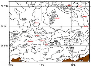
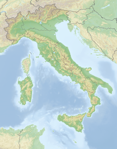
The Palinuro is an active underwater volcano in the southern part of the Tyrrhenian Sea west of the coast of the Cilento , which is about 65 km away.
The mountain range of the Palinuro complex extends over about 50 km in a west-east direction with a maximum extension of 22 km at the base and has several (5-8) peaks, the main peak of which is the Palinuro, which is up to 70 m below the Water surface rises.
In the event of an eruption of the volcano or landslides on its flanks, tsunamis can be expected, which could reach the coast in around 20 minutes.
literature
- Girolamo Milano, Salvatore Passaro, Mario Sprovieri: Present-day knowledge on the Palinuro Seamount (south-eastern Tyrrhenian Sea) . In: Bollettino di Geofisica Teorica ed Applicata , Vol. 53, No. 4, December 2012, pp. 403-416.
- Anne Westhues: Massive sulfides drilled at a submarine volcanic complex associated with an island arc. Palinuro volcanic complex . Master's thesis, University of Münster, 2009.
- Teresa Trua, Giancarlo Serri, Michael Marani: Geochemical features and geodynamic significance of the southern Tyrrhenian backarc basin . In: Luigi Beccaluva (Ed.): Cenozoic volcanism in the Mediterranean Area . Geological Society of America, Boulder 2007, ISBN 978-0-8137-2418-8 , pp. 221-233.
Individual evidence
- ^ Sven Petersen: Drilling of Submarine Shallow-water Hydrothermal Systems in Volcanic Arcs of the Tyrrhenian Sea, Italy , December 2008
- ↑ Paul Kreiner: Feuerberg im Wasser , Reportage, in: Der Tagesspiegel , November 2, 2013, p. 36

