Palumeu (river)
|
Palumeu Paloemeu |
||
|
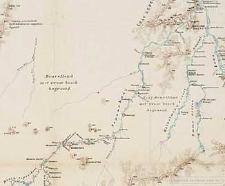
Tapanahony with the Palumeu at the bottom left on a map from 1905 |
||
| Data | ||
| location | Sipaliwini District , Suriname | |
| River system | Chestnuts | |
| Drain over | Tapanahony → Maroni → Atlantic | |
| origin | Border mountains with Brazil | |
| confluence | at the village of Palumeu with the Upper Tapanahony to the Tapanahony Coordinates: 3 ° 21 ′ 0 ″ N , 55 ° 26 ′ 0 ″ W 3 ° 21 ′ 0 ″ N , 55 ° 26 ′ 0 ″ W
|
|
The Palumeu (also outdated: Paloemeu) is a river in the south of Suriname in the Sipaliwini district .
It rises in the border mountains with Brazil and flows to the north on the left side of the Tapaje and on the right the Makrutubach. To the north, the Palumeu breaks through the western part of the Orange Mountains and passes the Kasikasima on the left . In this area it forms numerous rapids and waterfalls .
In the further course it flows along smaller villages and unites with the Upper Tapanahony at the village of the same name Palumeu, which is mainly inhabited by Tiriyos . At the confluence of the Upper Tapanahony with the Palumeu, the Tapanahony arises.
literature
- CFA Bruijning and J. Voorhoeve (main editors): Encyclopedie van Suriname . Elsevier , Amsterdam a. Brussel 1977, ISBN 90-10-01842-3 , p. 601.
