Paniri
| Paniri | ||
|---|---|---|
|
View of the Paniri volcano |
||
| height | 5946 m | |
| location | Región de Antofagasta , Chile | |
| Mountains | To the | |
| Coordinates | 22 ° 3 '33 " S , 68 ° 13' 40" W | |
|
|
||
| Type | Stratovolcano , extinguished | |
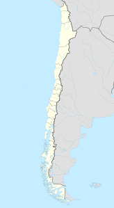
The volcano Paniri ( also : Panire) is a stratovolcano in the Antofagasta Region in Chile . It is located 25 kilometers southeast of the twin volcanoes San Pedro and San Pablo and 15 kilometers northwest of Cerro del León and has an altitude of 5946 meters. The Paniri has two peaks - one with a perfect peak, and a few hundred meters northwest a volcanic crater, which has been inactive for historical times.
The name of Paniri comes on the one hand from the northern Chilean language of the Atacameños , on the other hand it also refers to the recent history of the Atacama desert region . The young Thomás Panire, born near the volcanic peak, went down in Chilean history in 1780 as one of the most important freedom fighters for Túpac Amaru II , a descendant of the last Inca
See also
Individual evidence
- ↑ Volcán_Paniri (accessed June 28, 2016)

