
Ribalta Park

The Ribalta Park (Valencian: Parc Ribalta , Spanish: Parque Ribalta ) is a park in the center of the Spanish Mediterranean city of Castellón de la Plana . The park is now one of the city's main attractions.
Location and structure
The park is located in the western part of the city center and is bordered on all sides by streets. The Castellón bullring is just south of the park . The representative Independence Square with its modernist buildings borders the park to the northeast .
Today's park is almost rectangular in shape and is divided into a northern and southern part by a former section of Morella Street, which is no longer accessible to road traffic. Along the former street there are now a large number of benches decorated with mosaics .
In the northern part of the park there are two circular squares connected by a straight path. Today there is a round building on the western and larger square. In the eastern square there is a monument to the Spanish painter Francesc Ribalta . The trapezoidal southern part has a central circular square from which radiating paths lead off. In the middle of the square is an obelisk . There are many small winding paths between the radial paths. There is a larger pond on the western edge. Halfway down the former Morella Street there is a music pavilion on the southern side, which is connected to the central square of the southern part by a path.
A large number of monuments are distributed over the entire site.
history
The park was built in 1868 for the opening of the Valencia-Sagunto-Castellón railway line , a few hundred meters south of the station, and was intended to impress visitors to the city. D. Lluis Alfonso was responsible for the project and the design of the park. His design was based on English gardens .
In 1876 the park was expanded to the south. The design of the new section came from D. Lluis Alfonso, D. Salvador Fors and the gardener Francesc Tirado.
In 1898 the obelisk designed by Francesc Tomàs Traver was inaugurated in the central square of the southern part. The obelisk commemorates the defense of Castellón in the civil war against the troops of the Carlist between July 7th and 9th, 1837. The obelisk was destroyed in 1932 and rebuilt in 1980. In 1920 a new pond was created in the western part of the park. In 1934 a bandstand was built on the southern edge of the former Morella Street.
Today there are over 450 different plant species in the park.
gallery

Bandstand

Pond system
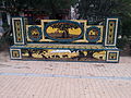
Typical mosaic park bench
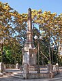
obelisk

Monument to Francesc Ribalta


Web links
Coordinates: 39 ° 59 '17.7 " N , 0 ° 2' 42.4" W.
Individual evidence
- ^ Parque Ribalta. Retrieved August 13, 2020 .
- ↑ a b La Guía Turística y Visual de Castellón . La Agencia, Castellón 2010, pp. 38–39 (Spanish, castellonturismo.com [PDF; 6.8 MB ; accessed on August 13, 2020]).
- ↑ a b c d e f g Ribalta Park. Retrieved August 13, 2020 .
- ^ The Ribalta Park, The Independencia Square And The Tetuán Square. Retrieved August 13, 2020 .