Paunsaugunt plateau

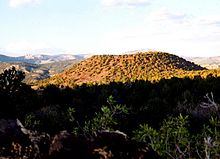
The Paunsaugunt Plateau (pronunciation: "PAWN-suh-gant") is a plateau in southwest Utah in the United States .
It extends to altitudes between 2100 m and 2800 m (7000 to 9300 feet ) and is located in northern Kane County and southwestern Garfield County . The plateau is about 16 kilometers wide and extends from the Sevier Plateau about 40 kilometers to the south and ends in the Pink Cliffs at the southern end.
It is drained by the East Fork Sevier River , which flows north on the plateau to meet the main arm of the Sevier River, which flows in a valley along the western side of the plateau. The plateau is severely rugged along the eastern flank, which is drained from the Paria River into the Colorado River , and is protected by Bryce Canyon National Park. Part of the Great Basin watershed runs along the plateau, and much of the plateau is part of the Dixie National Forest . Around 5.10 m of snow fall on the plateau each year and there are freeze-thaw cycles for around 200 days. The Utah State Route 12 , an All-American Road , runs through the Paunsaugunt plateau.
Geologically , the plateau was created about 10-20 million years ago by an ascent on the larger Colorado Plateau . The lifting caused the formation of crevices along the side of the plateau. Later erosion , particularly on the east side of Bryce Canyon National Park, has resulted in the creation of distinctive rock formations known as hoodoos, which are the park's trademark.
There is a small amount of pasture and forestry in the area, as well as mining and tourism.

See also
Web links
Coordinates: 37 ° 30 '0 " N , 112 ° 23' 4" W.