
Pen-y-Dinas (Gwynedd)

Pen-y-Dinas ( German "head of the place" - also called Cortin or Gortyn) is an Iron Age hill fort southeast of Talybont (also Tal-y-bont), north of Barmouth -Llanaber in Gwynedd in Wales . The entry in the COFLEIN (Catalog of archeology, buildings, industrial and maritime heritage in Wales) includes aerial photographs from 1948 to the present day, showing the Hillfort above the coastal plain.
A hill fort of the same name is located northwest of Llandudno in Conwy . With the prefix or suffix ( German "Ort" ) there are another 13 Hillforts in Wales (e.g. Craig-y-Dinas (Penygroes) is located nearby ).
Pen-y-Dinas occupies the sloping top of a westward spur on the north side of a valley. Although surrounded by natural cliffs on three sides and a massive wall and moat on the fourth, it is only a local fortification. The surrounding landscape that dominates the large hill forts was missing.
Pen-y-Dinas is located on the deeply cut river valley of the Ceunant Egryn. The oval fort, the interior of which slopes down to the west in one step, measures around 60.0 × 50.0 m and is provided in the north with a 4.0-5.0 m wide wall, which is now mostly covered with lawn.
- Pen-y-Dinas
Access

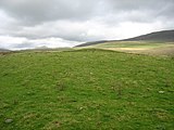
View over the Egryn Gorge

East Side
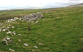
inner space


The majority of British hillforts were built between 1500 and 1000 BC. Many were in use until the early Middle Ages . In Pen-y-Dinas, OGS Crawford (1886–1957), one of the most renowned field archaeologists of the 20th century, carried out his first excavation in 1919. It showed two distinct, but not datable, construction phases. The lack of Roman pottery suggests that the fortress was no longer used after the Roman occupation (43 AD).
Outside the fortifications are the remains of a medieval village. They consist of the foundations of rectangular houses, courtyards and fields that prove the medieval extension. One of the fields overlaps the entrance to the fortress and shows that Pen-y-Dinas was already out of order at that time.
literature
- J. Ford-Johnston: Hillforts of the Iron Age in England and Wales: A Survey of the Surface Evidence. Liverpool University Press, Liverpool 1976.
- Michael Senior: Hillforts of Northern Wales Llygad Gwalch Cyf 2005 ISBN 0863819591
Web links
Coordinates: 52 ° 46 ′ 2.5 ″ N , 4 ° 4 ′ 1.7 ″ W.