Peron Islands
| Peron Islands | ||
|---|---|---|
| Satellite image of the Peron Islands | ||
| Waters | Timor Sea ( Indian Ocean ) | |
| Geographical location | 13 ° 10 ′ S , 130 ° 4 ′ E | |
|
|
||
| Number of islands | 2 | |
| Main island | North Peron Island | |
| Total land area | 24.6 km² | |
| Residents | uninhabited | |
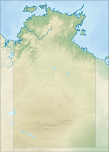
| Location map of the islands | ||
The Peron Islands are a small group of Australian islands off the western coast of the Northern Territory . They are located in Anson Bay about 5 km west of the settlement of Channel Point and 22 km northwest of the mouth of the Daly River .
The group consists of two flat sand islands with a total area of 24.6 km. Between the much larger North Peron Island (19.1 km²) and the south-east of it South Peron Island (5.5 km²) is a 2.5 km wide, but very shallow channel ( The Causeway ). North Peron Island reaches a height of almost 30 meters in a grassy hill to the north. Incidentally, the island shores are overgrown by mangroves .
The islands are uninhabited. However, they are often used by sailors and sport fishermen .
Individual evidence
- ↑ Sailing Directions (Enroute), Pub 175, North, West, and South Costs of Australia, prepared and published by the National Geospatial-Intelligence Agency, Bethesda, Maryland, 10th Edition, page 45 (PDF; 3.7 MB)
Web links
- Illustrated contribution by the Darwin Sailing Club (pdf; 134 kB)


