
Parsonage Kröbeln
The former parsonage Kröbeln is a historic building in the Kröbeln district of the spa town of Bad Liebenwerda in the Elbe-Elster district in southern Brandenburg . Here it is in the immediate vicinity of the local village church and the former village school . The building is now a listed building .
Building description and history
The village of Kröbeln was first mentioned in a document in 1289. The neighboring church dates from 1732.
The Kröbelner rectory was built between the years 1860 and 1880. The house is a two-story brick building with a gable roof. At that time, Ludwig Eduard Spieß (term of office: 1840–1875) and Ed. Arnold Beerhoff (term of office: 1875–1883) serving pastor of Kröbeln. Immediately to the left of the rectory is the village's former village school.
It is recorded in the local monument register under registration number 09135754. The associated farm building on the garden side is also under monument protection. The building made of field stone is single-storey and has a gable roof. Its creation time is dated between 1840 and 1850.
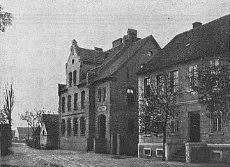
The Kröbelner rectory (right) in 1907.

Village school and rectory (2012)


Web links
Notes and individual references
- ↑ a b c Database of the Brandenburg State Office for the Preservation of Monuments and the State Archaeological Museum ( Memento of the original from December 9, 2017 in the Internet Archive ) Info: The archive link has been inserted automatically and has not yet been checked. Please check the original and archive link according to the instructions and then remove this notice. , accessed November 19, 2017.
- ↑ Renate Reyentanz: District Kröbeln . In: Chronicle of the City of Liebenwerda. Edited by Association for City Marketing and Economy Bad Liebenwerda eV Winklerdruck GmbH Gräfenhainichen, Bad Liebenwerda 2007, p. 252 to 253 .
- ↑ B.]: The school to Cröbeln (part 2) . In: The Black Magpie . No. 41 , 1907 (local history supplement to the Liebenwerdaer Kreisblatt ).
Coordinates: 51 ° 26 '42.7 " N , 13 ° 22' 3.3" E